North Banat District
|
North Banat District Severnobanatski okrug Севернобанатски округ Észak-bánsági körzet Sjevernobanatski okrug Districtul Banatul de Nord Severobanátsky okres Сивернобанатски окрух |
|
|---|---|
| District of Serbia | |
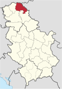
 Location of the North Banat District within Serbia |
|
| Country |
|
| Province | Vojvodina |
| Administrative center | Kikinda |
| Government | |
| • Commissioner | Nikola Lukač |
| Area | |
| • Total | 2,329 km2 (899 sq mi) |
| Population (2011 census) | |
| • Total | 146,690 |
| • Density | 63.0/km2 (163/sq mi) |
| ISO 3166 code | RS-03 |
| Municipalities | 6 |
| Settlements | 50 |
| - Cities and towns | 7 |
| - Villages | 43 |
| Website | www |
The North Banat District (Serbian: Севернобанатски округ, Severnobanatski okrug, Hungarian: Észak-bánsági körzet, Croatian: Sjevernobanatski okrug, Slovak: Severobanátsky okres, Romanian: Districtul Banatul de Nord, Rusyn: Сивернобанатски окрух, pronounced [sêʋeːrnobǎnaːtskiː ôkruːɡ]) is one of seven administrative districts of the autonomous province of Vojvodina, Serbia. It lies in the geographical regions of Banat and Bačka. According to the 2011 census, the district has a population of 146,690 inhabitants. The administrative center of the district is the city of Kikinda.
In the 9th century, the area was ruled by the Bulgarian-Slavic dukes Glad (in the east) and Salan (in the west), while in the 11th century, the eastern part of the area was ruled by duke Ahtum. From 11th to 16th century, during the administration of the medieval Kingdom of Hungary, the area was divided between the Csanadiensis County, Temesiensis County and Torontaliensis County in the east, and Csongradiensis County, Bacsensis County and Bodrogiensis County in the west. Part of the area was also located within the Cumania region. In 1526-1527, the area was ruled by the independent Serb ruler, emperor Jovan Nenad, while during Ottoman administration (16th-18th century), it was divided between the Temeşvar Eyalet in the east and the Sanjak of Segedin in the west.
...
Wikipedia
