North Babylon
| North Babylon, New York | |
|---|---|
| Hamlet and census-designated place | |
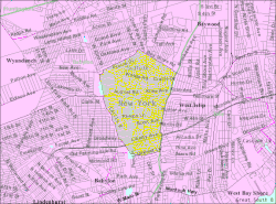
 U.S. Census map |
|
| Location within the state of New York | |
| Coordinates: 40°43′50″N 73°19′17″W / 40.73056°N 73.32139°WCoordinates: 40°43′50″N 73°19′17″W / 40.73056°N 73.32139°W | |
| Country | United States |
| State | New York |
| County | Suffolk |
| Area | |
| • Total | 3.4 sq mi (8.9 km2) |
| • Land | 3.4 sq mi (8.7 km2) |
| • Water | 0.04 sq mi (0.1 km2) |
| Elevation | 33 ft (10 m) |
| Population (2010) | |
| • Total | 17,509 |
| • Density | 5,100/sq mi (2,000/km2) |
| Time zone | Eastern (EST) (UTC-5) |
| • Summer (DST) | EDT (UTC-4) |
| ZIP code | 11703 |
| Area code(s) | 631 |
| FIPS code | 36-51440 |
| GNIS feature ID | 0958667 |
North Babylon is a hamlet and census-designated place (CDP) located in Suffolk County, on Long Island, in New York, United States. It is located approximately 25 miles east of New York City, at the Queens border. The population was 17,509 at the 2010 census.
North Babylon is a community in the Town of Babylon. It has a number of recreational areas such as Belmont Lake State park where walking, cycling, picnicking and boating are enjoyed. Phelps Lane pool is also a popular recreation area for swimming, tennis and relaxation.
The main commercial thoroughfare in North Babylon is Deer Park Avenue featuring a mix of strip malls, shopping centers, homes and schools. A portion of this road is known as New York State Route 231 from Sylvan Road to the Northern State Parkway in Dix Hills. Deer Park Avenue gained notoriety as a very popular "cruise strip" where thousands of people would congregate in the shopping centers on the weekends to show off their cars, along with illegal drag racing on the highway portion of Route 231 between Montauk Highway and Hunter Avenue.
School-age children attend the North Babylon Union Free School District, home of the Bulldogs, along with a number of private and parochial schools in the area.
According to the United States Census Bureau, the census-designated place has a total area of 3.4 square miles (8.8 km2), of which 3.4 square miles (8.8 km2) is land, and 0.1 square miles (0.26 km2) (1.46%) is water.
As of the census of 2000, there were 17,877 people, 6,146 households, and 4,707 families residing in the hamlet. The population density was 5,309.8 per square mile (2,048.2/km²). There were 6,271 housing units at an average density of 1,862.6 per square mile (719.2/km2). The racial makeup of the hamlet was 84.9% White, 6.2% African American, 0.17% Native American, 2.09% Asian, 0.03% Pacific Islander, 1.95% from other races, and 1.63% from two or more races. Hispanic or Latino of any race were 7.34% of the population.
...
Wikipedia

