Normal, IL
| Normal, Illinois | |
|---|---|

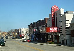
Uptown Normal, looking east on North Street, 2011
|
|
| Location within the state of Illinois | |
| Coordinates: 40°30′44″N 88°59′19″W / 40.51222°N 88.98861°WCoordinates: 40°30′44″N 88°59′19″W / 40.51222°N 88.98861°W | |
| Country | United States |
| State | Illinois |
| County | McLean |
| Townships | Normal, Dry Grove, Towanda |
| Settled | 1854 |
| Founded | February 1865 |
| Incorporated | February 25, 1867 |
| Government | |
| • Mayor | Chris Koos |
| • City Manager | Mark R. Peterson |
| Area | |
| • Total | 18.41 sq mi (47.7 km2) |
| • Land | 18.35 sq mi (47.5 km2) |
| • Water | 0.06 sq mi (0.2 km2) 0.33% |
| Elevation | 869 ft (265 m) |
| Population (2010) | |
| • Total | 52,497 |
| • Estimate (2013) | 54,664 |
| • Density | 2,900/sq mi (1,100/km2) |
| Time zone | Central Standard Time (USA) (UTC−6) |
| • Summer (DST) | Central Daylight Time (UTC−5) |
| Area code(s) | 309 |
| Website | www.normal.org |
Normal is a town in McLean County, Illinois, United States. As of the 2010 census, the town's population was 52,497. Normal is the smaller of two principal municipalities of the Bloomington–Normal metropolitan area, and Illinois' seventh most populous community outside of the Chicago metropolitan area. Normal's mayor is Chris Koos.
The main campus of Illinois' oldest public university, Illinois State University, a fully accredited four-year institution, is in Normal, as is Heartland Community College, a fully accredited two-year institution. There is also a satellite campus of Lincoln College, which offers associate degrees as well as four-year programs.
A large percentage of residents of Normal are employed by Illinois State University, State Farm Insurance (Corporate Headquarters in Bloomington), Country Financial (Corporate Headquarters in Bloomington), and Unit 5 schools.
The town was laid out with the name North Bloomington on June 7, 1854 by Joseph Parkinson. From its founding, it was generally recognized that Jesse W. Fell was the force behind the creation of the town. He had arranged for the new railroad, which would soon become the Chicago and Alton Railroad, to pass west of Bloomington then curving to cross the Illinois Central Railroad at a point where he owned or controlled land. Most of the original town lies south of these tracks, with Beaufort Street as its northern limit, and some blocks west of the Illinois Central and north of the tracks. Fell, his brothers, and associates quickly laid out many additions to the original town.
...
Wikipedia

