Noordoostpolder
| Noordoostpolder | |||
|---|---|---|---|
| Municipality | |||

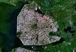
Satellite image of Noordoostpolder
|
|||
|
|||
 Location in Flevoland |
|||
| Coordinates: 52°43′N 5°45′E / 52.717°N 5.750°ECoordinates: 52°43′N 5°45′E / 52.717°N 5.750°E | |||
| Country | Netherlands | ||
| Province | Flevoland | ||
| Established | 1 January 1962 | ||
| Government | |||
| • Body | Municipal council | ||
| • Mayor | Aucke van der Werff (CDA) | ||
| Area | |||
| • Total | 595.43 km2 (229.90 sq mi) | ||
| • Land | 460.31 km2 (177.73 sq mi) | ||
| • Water | 135.12 km2 (52.17 sq mi) | ||
| Elevation | −3 m (−10 ft) | ||
| Population (May 2014) | |||
| • Total | 46,450 | ||
| • Density | 101/km2 (260/sq mi) | ||
| Time zone | CET (UTC+1) | ||
| • Summer (DST) | CEST (UTC+2) | ||
| Postcode | 8300–8319 | ||
| Area code | 0527 | ||
| Website | www |
||
Noordoostpolder ([ˈnoːrtoːstˌpɔldər], English: North-East Polder) is a municipality in the Flevoland province in the central Netherlands. Formerly, it was also called Urker Land. Emmeloord is the administrative center, located in the heart of the Noordoostpolder. The municipality has the largest land area in the Netherlands. (Lelystad and Terschelling both technically have more total area, but in both cases it is mostly water area.)
For history see Zuiderzee Works.
The population centres are Bant, Creil, Emmeloord, Ens, Espel, Kraggenburg, Luttelgeest, Marknesse, Nagele, Rutten, and Tollebeek.
The former island of Schokland, is now a museum.
The town and former island of Urk, in the southwest, now surrounded by the Noordoostpolder, is a separate municipality.
...
Wikipedia


