Nirim
|
Nirim נִירִים |
|
|---|---|

Nirim defenders in 1948
|
|
| Coordinates: 31°20′5.64″N 34°23′45.23″E / 31.3349000°N 34.3958972°ECoordinates: 31°20′5.64″N 34°23′45.23″E / 31.3349000°N 34.3958972°E | |
| District | Southern |
| Council | Eshkol |
| Affiliation | Kibbutz Movement |
| Founded | 6 October 1946 |
| Founded by | Hashomer Hatzair members |
| Area | 22,000 dunams (22 km2 or 8 sq mi) |
| Population (2015) | 357 |
| • Density | 16/km2 (42/sq mi) |
| Website | www.nirim.co.il |
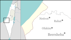
Nirim (Hebrew: נִירִים, lit. Meadows) is a kibbutz in the northwestern Negev in Israel. Located near the border with the Gaza Strip, about 7 kilometers east of Khan Yunis, it falls under the jurisdiction of Eshkol Regional Council. In 2015 it had a population of 357.
The kibbutz was established in June 1946 as part of the 11 points in the Negev plan aimed at establishing a Jewish presence in the Negev in order to claim it as part of a future Jewish state. It was named after the Nir brigade of the Hashomer Hatzair youth movement, some of whose members helped establish the kibbutz, and was originally established on a site called "Dangour", where kibbutz Sufa is now. One of the founders was Dan Zur, who became one of Israel's leading landscape architects.
At the outbreak of the 1948 Arab–Israeli War on 15 May 1948, the kibbutz was first Jewish settlement in Israel to be attacked by the Egyptian army, in the Battle of Nirim. It had 39 defenders. During the battle, the Egyptians came within 25 meters of the kibbutz perimeter and eight of the kibbutz defenders were killed, before Egyptians withdrew. All of the houses were destroyed in the attack.
Nirim remained an Israel Defense Forces (IDF) outpost against the Egyptian army throughout the war. After the war, the IDF wanted the site because of its strategic location, while the kibbutzniks wanted to move north, to the line of 200 millimeters of rain a year, so the kibbutz moved some 15 kilometers northeast to its present location, next to the site of an ancient synagogue at Horvot Maon.
...
Wikipedia

