Ninilchik, Alaska
| Ninilchik, Alaska | |
|---|---|
| CDP | |

Ninilchik Russian Church
|
|
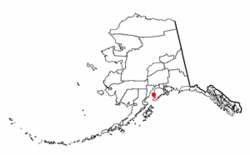
 Location of Ninilchik, Alaska |
|
| Coordinates: 60°02′47″N 151°40′02″W / 60.04639°N 151.66722°WCoordinates: 60°02′47″N 151°40′02″W / 60.04639°N 151.66722°W | |
| Country | United States |
| State | Alaska |
| Borough | Kenai Peninsula |
| Government | |
| • Borough mayor | Mike Navarre |
| • State senator | Gary Stevens (R) |
| • State rep. | Paul Seaton (R) |
| Area | |
| • Total | 207.6 sq mi (537.7 km2) |
| • Land | 207.6 sq mi (537.6 km2) |
| • Water | 0.0 sq mi (0.1 km2) |
| Population (2010) | |
| • Total | 883 |
| • Density | 4.3/sq mi (1.6/km2) |
| Time zone | Alaska (AKST) (UTC-9) |
| • Summer (DST) | AKDT (UTC-8) |
| ZIP code | 99639 |
| Area code(s) | 907 |
| FIPS code | 02-54480 |
Ninilchik (Russian: Нинильчик) is a census-designated place (CDP) in Kenai Peninsula Borough, Alaska, United States. At the 2010 census the population was 883.
It is considered an Alaska Native village under the Alaska Native Claims Settlement Act. In the 1970s, villagers formed the Ninilchik Native Association Incorporated. Later the Ninilchik Traditional Council (NTC) was established as the government of Alaska Natives in this area.
The Alaska Native people of Ninilchik have ancestors of Aleut and Alutiiq (Sugpiaq) descent, as well as some Dena'ina. Many also include Russian ancestors, from a couple of men who settled here with their Alutiiq wives and children in 1847, and later migrants. Russian was widely spoken in the village for years. Due to the community's isolation, this Russian dialect continued much in its mid-19th century form. With some surviving speakers, it has been studied in the 21st century.
Ninilchik is on the west side of the Kenai Peninsula on the coast of Cook Inlet, 38 miles (61 km) southwest of Kenai, and 100 miles (160 km) southwest of Anchorage. Road access is by the Sterling Highway. By actual road miles it is a distance of 188 miles (303 km) from Anchorage and 44 miles (71 km) from Homer.
According to the United States Census Bureau, the CDP has a total area of 207.6 square miles (538 km2), of which, 207.6 square miles (538 km2) of it is land and 0.04 square miles (0.10 km2) of it (0.01%) is water.
...
Wikipedia
