Kenai Peninsula Borough, Alaska
| Kenai Peninsula Borough, Alaska | |
|---|---|
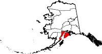
 Location in the U.S. state of Alaska |
|
 Alaska's location in the U.S. |
|
| Incorporated | January 1, 1964 |
| Named for | Kenai Peninsula |
| Seat | Soldotna |
| Largest city | Kenai |
| Area | |
| • Total | 24,752 sq mi (64,107 km2) |
| • Land | 16,075 sq mi (41,634 km2) |
| • Water | 8,677 sq mi (22,473 km2), 35.1% |
| Population (est.) | |
| • (2015) | 58,059 |
| • Density | 3.4/sq mi (1/km²) |
| Congressional district | At-large |
| Time zone | Alaska: UTC-9/-8 |
| Website | www |
Kenai Peninsula Borough is a borough of the U.S. state of Alaska. As of the 2010 census, the population was 55,400. The borough seat is Soldotna.
The borough includes the Kenai Peninsula and adjacent areas of the mainland of Alaska.
The borough has a total area of 24,752 square miles (64,110 km2), of which 16,075 square miles (41,630 km2) is land and 8,677 square miles (22,470 km2) (3.4%) is water.
Bear Lake, and the Trail Lakes, have been the site of salmon enhancement activities. Both sites are managed by the Cook Inlet Aquaculture Association Some of the fish hatched at these facilities are released into the famous Homer fishing hole. Cook Inlet Keeper and the Cook Inlet Regional Citizen's Advisory Council are groups that attempt to influence public policy on the use of the areas resources.
As of the census of 2000, there were 49,700 people, 18,400 households, and 12,700 families residing in the borough. The population density was 1/km² (3/sq mi). There were 24,900 housing units at an average density of 2 per square mile (1/km²). The racial makeup of the borough was 86% white, 7% Native American, 2% Hispanic or Latino (any race), and 4% from two or more races. Black or African Americans, Asians, and Pacific Islanders each were less than 1% of the population. Just under 1% were from other races combined. 1.92% reported speaking Russian at home, while 1.74% speak Spanish.
...
Wikipedia
