Nikiforos Fokas
|
Nikiforos Fokas Νικηφόρος Φωκάς |
|
|---|---|
| Coordinates: 35°18′N 24°24′E / 35.300°N 24.400°ECoordinates: 35°18′N 24°24′E / 35.300°N 24.400°E | |
| Country | Greece |
| Administrative region | Crete |
| Regional unit | Rethymno |
| Municipality | Rethymno |
| • Municipal unit | 95.6 km2 (36.9 sq mi) |
| Population (2011) | |
| • Municipal unit | 8,911 |
| • Municipal unit density | 93/km2 (240/sq mi) |
| Time zone | EET (UTC+2) |
| • Summer (DST) | EEST (UTC+3) |
| Vehicle registration | ΡΕ |
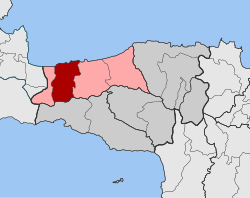
Nikiforos Fokas (Greek: Νικηφόρος Φωκάς) is a former municipality in the Rethymno regional unit, Crete, Greece. Since the 2011 local government reform it is part of the municipality Rethymno, of which it is a municipal unit. The municipal unit has an area of 95.641 km2 (36.927 sq mi). It was named after the 10th century Byzantine Emperor Nikephoros II Phokas, who retook the island from the Muslims. Population 8,911 (2011). The seat of the municipality was in Gonia. The ancient city of Eleutherna is located within the municipal unit.
...
Wikipedia


