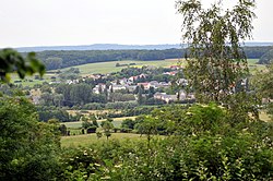
Niederanven
|
Niederanven Nidderaanwen |
||
|---|---|---|
| Commune | ||
 |
||
|
||
 Map of Luxembourg with Niederanven highlighted in orange, and the canton in dark red |
||
| Coordinates: 49°39′05″N 6°15′20″E / 49.6514°N 6.2556°ECoordinates: 49°39′05″N 6°15′20″E / 49.6514°N 6.2556°E | ||
| Country |
|
|
| Canton | Luxembourg | |
| Government | ||
| • Mayor | Raymond Weydert | |
| Area | ||
| • Total | 41.36 km2 (15.97 sq mi) | |
| Area rank | 11th of 105 | |
| Highest elevation | 429 m (1,407 ft) | |
| • Rank | 28th of 105 | |
| Lowest elevation | 241 m (791 ft) | |
| • Rank | 49th of 105 | |
| Population (2014) | ||
| • Total | 5,663 | |
| • Rank | 22nd of 105 | |
| • Density | 140/km2 (350/sq mi) | |
| • Density rank | 49th of 105 | |
| Time zone | CET (UTC+1) | |
| • Summer (DST) | CEST (UTC+2) | |
| LAU 2 | LU00011005 | |
| Website | niederanven.lu | |
Niederanven (Luxembourgish: Nidderaanwen) is a commune and town in Luxembourg. Its population is 5,440 and it is located north-east of Luxembourg City. Part of the Luxembourg-Findel International Airport is located within Niederanven (and partly in Sandweiler).
The A1 and the N1 roadways intersect in Niederanven.
As of 2001[update], the town of Niederanven, which lies in the north-east of the commune, has a population of 1,476. Other towns within the commune include Ernster, Hostert, Oberanven, Rameldange, Senningen, Senningerberg, and Waldhof.
Niederanven is a founding member of the Douzelage, a unique town twinning association of 24 towns across the European Union. This active town twinning began in 1991 and there are regular events, such as a produce market from each of the other countries and festivals. Discussions regarding membership are also in hand with three further towns (Agros in Cyprus, Škofja Loka in Slovenia, and Tryavna in Bulgaria).
...
Wikipedia

