Niagara, North Dakota
| Niagara, North Dakota | |
|---|---|
| City | |

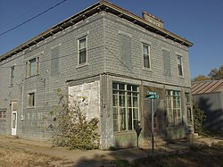
At the corner of Ransom and Second
|
|
 |
|
| Coordinates: 47°59′49″N 97°52′10″W / 47.99694°N 97.86944°WCoordinates: 47°59′49″N 97°52′10″W / 47.99694°N 97.86944°W | |
| Country | United States |
| State | North Dakota |
| County | Grand Forks |
| Metro | Greater Grand Forks |
| Area | |
| • Total | 0.97 sq mi (2.51 km2) |
| • Land | 0.94 sq mi (2.43 km2) |
| • Water | 0.03 sq mi (0.08 km2) |
| Elevation | 1,457 ft (444 m) |
| Population (2010) | |
| • Total | 53 |
| • Estimate (2015) | 51 |
| • Density | 56.4/sq mi (21.8/km2) |
| Time zone | Central (CST) (UTC-6) |
| • Summer (DST) | CDT (UTC-5) |
| ZIP code | 58266 |
| Area code(s) | 701 |
| FIPS code | 38-56780 |
| GNIS feature ID | 1030403 |
Niagara is a city in Grand Forks County, North Dakota, United States. It is part of the "Grand Forks, ND-MN Metropolitan Statistical Area" or "Greater Grand Forks". The population was 53 at the 2010 census. Niagara was founded in 1883.
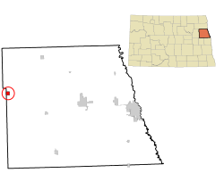
Niagara is located at 47°59′49″N 97°52′10″W / 47.99694°N 97.86944°W (47.997001, -97.869353).
According to the United States Census Bureau, the city has a total area of 0.97 square miles (2.51 km2), of which, 0.94 square miles (2.43 km2) is land and 0.03 square miles (0.08 km2) is water.
As of the census of 2010, there were 53 people, 23 households, and 15 families residing in the city. The population density was 56.4 inhabitants per square mile (21.8/km2). There were 29 housing units at an average density of 30.9 per square mile (11.9/km2). The racial makeup of the city was 98.1% White and 1.9% from two or more races. Hispanic or Latino of any race were 1.9% of the population.
...
Wikipedia
