Newville, Pennsylvania
| Newville, Pennsylvania | |
|---|---|
| Borough | |

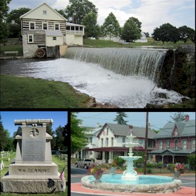
Top - Laughlin Mill, Bottom left - William Denning Monument, Bottom right - Newville Fountain Square
|
|
| Coordinates: 40°10′11″N 77°24′07″W / 40.16972°N 77.40194°WCoordinates: 40°10′11″N 77°24′07″W / 40.16972°N 77.40194°W | |
| Country | United States |
| State | Pennsylvania |
| County | Cumberland |
| Government | |
| • Type | Borough Council |
| • Mayor | William A. Toth |
| Area | |
| • Total | 0.43 sq mi (1.11 km2) |
| • Land | 0.42 sq mi (1.09 km2) |
| • Water | 0.008 sq mi (0.02 km2) |
| Elevation | 528 ft (161 m) |
| Population (2010) | |
| • Total | 1,326 |
| • Density | 3,161/sq mi (1,220.6/km2) |
| Time zone | Eastern (EST) (UTC-5) |
| • Summer (DST) | EDT (UTC-4) |
| ZIP code | 17241 |
| Area code(s) | 717 |
| Website | www |
Newville is a borough in Cumberland County, Pennsylvania, United States, west of Carlisle. The population was 1,326 at the 2010 census. It is part of the Harrisburg–Carlisle Metropolitan Statistical Area.
Newville is served by the Big Spring School District.
Newville is located in west-central Cumberland County at 40°10′11″N 77°24′7″W / 40.16972°N 77.40194°W (40.169614, −77.402029), on the west side of Big Spring Creek, a tributary of Conodoguinet Creek and part of the Susquehanna River watershed. The borough is bordered on the north and west by North Newton Township and on the south and east by West Pennsboro Township.
Pennsylvania Route 641 passes through the borough as Main Street, leading west 9 miles (14 km) to Newburg and east 11 miles (18 km) to Carlisle, the county seat. Pennsylvania Route 233 (High Street) crosses PA 641 at the center of town and leads north 16 miles (26 km) to Landisburg and southeast 5 miles (8 km) to Interstate 81 near Dickinson. Pennsylvania Route 533 leads southwest from Newville 11 miles (18 km) to Shippensburg.
...
Wikipedia

