Newry, Pennsylvania
| Newry, Pennsylvania | |
|---|---|
| Borough | |

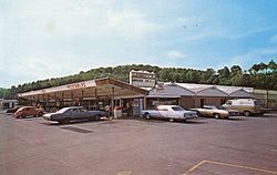
Farmers market
|
|
 Location of Newry in Blair County, Pennsylvania. |
|
| Location of Newry in Blair County, Pennsylvania. | |
| Coordinates: 40°23′36″N 78°26′06″W / 40.39333°N 78.43500°WCoordinates: 40°23′36″N 78°26′06″W / 40.39333°N 78.43500°W | |
| Country | United States |
| State | Pennsylvania |
| County | Blair |
| Settled | 1793 |
| Incorporated | 1876 |
| Government | |
| • Type | Borough Council |
| Area | |
| • Total | 0.10 sq mi (0.25 km2) |
| • Land | 0.10 sq mi (0.25 km2) |
| • Water | 0.00 sq mi (0.00 km2) |
| Population (2010) | |
| • Total | 270 |
| • Estimate (2016) | 266 |
| • Density | 2,714.29/sq mi (1,047.10/km2) |
| Time zone | Eastern (EST) (UTC-5) |
| • Summer (DST) | EDT (UTC-4) |
| Zip code | 16665 |
| Area code(s) | 814 |
| FIPS code | 42-54024 |
Newry is a borough in Blair County, Pennsylvania, United States. The population was 270 at the 2010 census. It is part of the Altoona, PA Metropolitan Statistical Area and one of the communities comprising the Altoona Urban Area.
It was named after the town of Newry in Northern Ireland.
Newry is located at 40°23′36″N 78°26′6″W / 40.39333°N 78.43500°W (40.393223, -78.435085).
According to the United States Census Bureau, the borough has a total area of 0.1 square miles (0.26 km2), all of it land.
South of Newry, the stream known as Poplar Run flows to the east towards the Frankstown Branch of the Juniata River.
As of the census of 2000, there were 245 people, 107 households, and 61 families residing in the borough. The population density was 2,550.2 people per square mile (946.0/km²). There were 116 housing units at an average density of 1,207.4 per square mile (447.9/km²). The racial makeup of the borough was 97.14% White, 0.82% African American, 0.82% from other races, and 1.22% from two or more races. Hispanic or Latino of any race were 1.22% of the population.
...
Wikipedia

