Newark Light Rail
| Newark Light Rail | |||
|---|---|---|---|
 |
|||

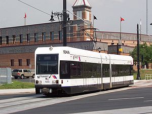
A Newark Light Rail car crosses Broad Street by Riverfront Stadium in Newark, pulling into the Newark Broad Street station.
|
|||
| Overview | |||
| Type | Light rail/Tram | ||
| System | New Jersey Transit | ||
| Locale | Essex County | ||
| Termini |
Newark Penn Station Grove Street (City Subway Line) Newark Broad St. (Broad Street Extension) |
||
| Stations | 5 (Broad Street Extension outbound) 4 (Broad Street Extension inbound) 11 (City Subway Line) |
||
| Services | 2 | ||
| Website | NJ Transit | ||
| Operation | |||
| Opened | May 16, 1935 (City Subway) 2006 (Broad Street Extension) |
||
| Owner |
New Jersey Transit (within Newark) Norfolk Southern (in Belleville and Bloomfield) |
||
| Operator(s) | New Jersey Transit Bus Operations | ||
| Rolling stock | 20 Kinki Sharyo LRVs | ||
| Technical | |||
| Line length | 6.2 mi (10.0 km) | ||
| Track gauge | 4 ft 8 1⁄2 in (1,435 mm) | ||
| Minimum radius | 33 ft (10.058 m) | ||
| Electrification | 750 V (DC) overhead lines | ||
|
|||
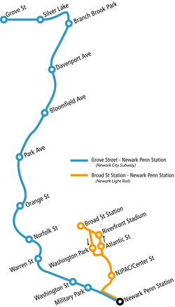
The Newark Light Rail (NLR) is a light rail system under New Jersey Transit Bus Operations serving Newark, New Jersey. The service consists of two segments, the original Newark City Subway (NCS), and the extension to Broad Street station. The combined service was officially inaugurated on July 17, 2006.
The Newark City Subway service is the longer and older of the two segments. The line is a "subway-surface" light rail line which runs underground downtown and above-ground in outlying areas. Before becoming a part of the Newark Light Rail service, it was also known as the #7-City Subway line, an NJT Bus Operations route number that still applies internally (during system closures, buses would also bear the number "7 City Subway").
The segment is 5.3 mi (8.5 km) long and runs between Grove Street in Bloomfield and Newark Penn Station. Penn Station is a major transportation hub with connections to the PATH rapid transit system to Manhattan, multiple bus routes, and Amtrak.
The line opened in 1935 along the old Morris Canal right-of-way, from Broad Street (now known as Military Park) to Heller Parkway.Works Progress Administration artists decorated the underground stations with art-deco scenes from life on the defunct Morris Canal. The southernmost part, south of Warren Street, was capped with a new road, known as Raymond Boulevard. Only one grade crossing was present on the original subway; the line crosses Orange Street at grade so it can pass over the below-grade Delaware, Lackawanna and Western Railroad (now NJT Morristown Line) immediately to the north.
...
Wikipedia

