New York State Route 292
| New York State Route 292 | ||||
|---|---|---|---|---|

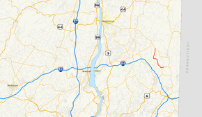
Map of the Hudson Valley with NY 292 highlighted in red
|
||||
| Route information | ||||
| Maintained by NYSDOT | ||||
| Length: | 7.58 mi (12.20 km) | |||
| Existed: | January 1, 1970 – present | |||
| Major junctions | ||||
| South end: |
|
|||
| North end: |
|
|||
| Location | ||||
| Counties: | Putnam, Dutchess | |||
| Highway system | ||||
|
||||
New York State Route 292 (NY 292) is a short state highway in the Hudson Valley of New York in the United States, bridging Putnam and Dutchess counties. The southern terminus of the route is at an intersection with NY 311 in the town of Patterson, and the northern terminus is at a junction with NY 55 in the town of Pawling. NY 292 traverses mostly rural areas as it heads northwestward through Patterson and Pawling. Along the way, NY 292 passes along the southern and western edges of Whaley Lake.
The portion of NY 292 between West Patterson and Whaley Lake originated as a dirt road named the Patterson–Dutchess County Line Road. This road was reconstructed in 1919 and became part of NY 39, a highway extending from Poughkeepsie to Patterson by way of West Pawling, in the 1920s. In the 1930 renumbering of state highways in New York, the segment of NY 39 from East Fishkill to West Patterson was incorporated into the new NY 52. By the end of the 1930s, the portion of NY 52 from Stormville to West Patterson was renumbered to NY 216. In 1970, NY 216 was truncated to its current length and NY 216's former alignment from West Pawling to Patterson was renumbered to NY 292.
...
Wikipedia

