New Washington, Indiana
| New Washington, Indiana | |
|---|---|
| CDP | |

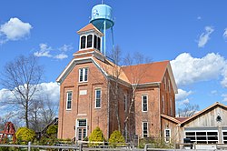
Former school
|
|
 Location in the state of Indiana |
|
| Coordinates: 38°33′45″N 85°32′29″W / 38.56250°N 85.54139°WCoordinates: 38°33′45″N 85°32′29″W / 38.56250°N 85.54139°W | |
| Country | United States |
| State | Indiana |
| County | Clark |
| Township | Washington |
| Area | |
| • Total | 5.22 sq mi (13.52 km2) |
| • Land | 5.21 sq mi (13.49 km2) |
| • Water | 0.02 sq mi (0.04 km2) |
| Elevation | 719 ft (219 m) |
| Population (2010) | |
| • Total | 566 |
| • Density | 109/sq mi (42.0/km2) |
| Time zone | Eastern (EST) (UTC-5) |
| • Summer (DST) | EDT (UTC-4) |
| ZIP code | 47162 |
| Area code(s) | 812 |
| FIPS code | 18-53820 |
| GNIS feature ID | 0440123 |
New Washington is a census-designated place (CDP) in Clark County, Indiana, United States. As of the 2010 census, the population was 566.
New Washington is located in northeastern Clark County at 38°33′45″N 85°32′29″W / 38.56250°N 85.54139°W (38.562575, -85.541524).Indiana State Road 62 runs through the center of the community, leading north then east 19 miles (31 km) to Madison and southwest 24 miles (39 km) to Jeffersonville across the Ohio River from Louisville, Kentucky.
According to the United States Census Bureau, the CDP has a total area of 5.2 square miles (13.5 km2), of which 0.02 square miles (0.04 km2), or 0.29%, is water.
As of the census of 2000, there were 547 people, 228 households, and 163 families residing in the CDP. The population density was 104.8 people per square mile (40.5/km²). There were 253 housing units at an average density of 48.5/sq mi (18.7/km²). The racial makeup of the CDP was 99.63% White and 0.37% African American.
...
Wikipedia
