New Hampshire Route 116
| New Hampshire Route 116 | ||||
|---|---|---|---|---|

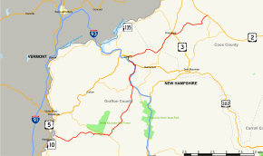
Map of northwestern New Hampshire with NH 116 highlighted in red
|
||||
| Route information | ||||
| Maintained by NHDOT | ||||
| Length: | 48.605 mi (78.222 km) | |||
| Major junctions | ||||
| West end: |
|
|||
| East end: |
|
|||
| Location | ||||
| Counties: | Grafton, Coos | |||
| Highway system | ||||
|
||||
New Hampshire Route 116 (abbreviated NH 116) is a 48.605-mile-long (78.222 km) east–west highway in northern New Hampshire, United States. NH 116 is a scenic rural highway stretching from Haverhill, which lies along the Connecticut River, to Jefferson, in the White Mountains Region.
The eastern terminus of NH 116 is at U.S. Route 2 (the Presidential Highway) in Jefferson. The highway winds southwest through the towns of Whitefield and Bethlehem to Littleton, then turns south, concurrent with NH 18, to the village of Franconia. The road then runs southwest through Easton to NH 112, then turns west to reach its western terminus. Major intersections include Interstate 93 and U.S. Route 3. The western terminus is in North Haverhill at the junction with New Hampshire Route 10, which runs north and south along the Connecticut River.
...
Wikipedia

