New Florence, PA
| New Florence, Pennsylvania | |
|---|---|
| Borough | |

Ligonier Street
|
|
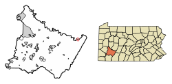
 Location of New Florence in Westmoreland County, Pennsylvania. |
|
| Location of New Florence in Westmoreland County, Pennsylvania. | |
| Coordinates: 40°22′47″N 79°04′29″W / 40.37972°N 79.07472°WCoordinates: 40°22′47″N 79°04′29″W / 40.37972°N 79.07472°W | |
| Country | United States |
| State | Pennsylvania |
| County | Westmoreland |
| Incorporated | May 27, 1865 |
| Government | |
| • Type | Borough Council |
| Area | |
| • Total | 0.33 sq mi (0.85 km2) |
| • Land | 0.33 sq mi (0.85 km2) |
| • Water | 0.00 sq mi (0.00 km2) |
| Elevation | 1,079 ft (329 m) |
| Population (2010) | |
| • Total | 689 |
| • Estimate (2016) | 659 |
| • Density | 2,009.15/sq mi (776.52/km2) |
| Time zone | Eastern (EST) (UTC-5) |
| • Summer (DST) | EDT (UTC-4) |
| Zip code | 15944 |
| Area code(s) | 724 Exchange: 235 |
| FIPS code | 42-53544 |
New Florence is a borough in Westmoreland County, Pennsylvania, United States. It was named for the city of Florence in Italy. The population was 689 as of the 2010 census, which is a decrease from 784 recorded by 2000 census.
New Florence is located at 40°22′47″N 79°4′29″W / 40.37972°N 79.07472°W (40.379707, -79.074841).
According to the United States Census Bureau, the borough has a total area of 0.4 square miles (1.0 km2), of which, 0.3 square miles (0.78 km2) of it is land and 0.04 square miles (0.10 km2) of it (5.56%) is water.
New Florence is bordered by St. Clair Township to the east, south and west. Across the Conemaugh River in Indiana County to the north, New Florence runs adjacent with West Wheatfield Township and has a direct connector via 9th Street Bridge.
As of the census of 2000, there were 784 people, 331 households, and 225 families residing in the borough. The population density was 2,242.4 people per square mile (864.9/km²). There were 365 housing units at an average density of 1,044.0 per square mile (402.6/km²). The racial makeup of the borough was 99.11% White, 0.13% Native American, 0.13% from other races, and 0.64% from two or more races. Hispanic or Latino of any race were 0.13% of the population.
...
Wikipedia

