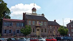
New Castle County Court House
|
New Castle Court House Museum
|
|

New Castle Court House Museum.
|
|
| Location | 211 Delaware St., New Castle, Delaware |
|---|---|
| Coordinates | 39°39′35″N 75°33′49″W / 39.65972°N 75.56361°WCoordinates: 39°39′35″N 75°33′49″W / 39.65972°N 75.56361°W |
| Built | 1730 |
| Architectural style | Georgian |
| NRHP Reference # | 72000285 |
| Significant dates | |
| Added to NRHP | November 28, 1972 |
| Designated NHL | November 28, 1972 |
The New Castle Court House Museum is the center of a circle with a 12-mile radius that defines most of the border between the states of Delaware and Pennsylvania and parts of the borders between Delaware and New Jersey and Maryland.
It is one of the oldest courthouses in the United States and has played a role in a number of historic events. It was declared a National Historic Landmark in 1972. The building is also a contributing property to a second National Historic Landmark, the New Castle Historic District. It is part of First State National Historical Park.
In 1682, James, the Duke of York gave William Penn a deed for land consisting of a 12-mile circle around the town of New Castle. The borders established by this deed were almost immediately contested by Lord Baltimore, proprietor of the colony of Maryland, and thus began an 87-year legal struggle between the two families. Penn first commissioned a survey of the circle in 1701. As part of the boundary dispute, the two families created a Commission led by Governor Patrick Gordon of Pennsylvania and Governor Samuel Ogle of Maryland, and the Commission met in the New Castle Court House four times in 1732 and 1733. A subsequent Commission, including William Allen and Benjamin Chew met in the Court House in 1750, where it was agreed by both sides that the cupola of the Court House building would be used as the center of the 12 mile circle. The Commission met in the Court House again in 1751 and 1760. The final survey of the borders as part of the boundary dispute was conducted in 1763 by Charles Mason and Jeremiah Dixon, who ran a series of chains on a straight 12 mile line from the Court House. Their Mason–Dixon line has been used as the unofficial dividing line between the north and the south. The Penns and Calverts agreed to the results of the Mason-Dixon survey, and their border dispute was resolved when the British crown ratified the border in 1769. The circle was surveyed again in 1849 by the Army's Corps of Topographical Engineers, and again in 1892 by the U.S. Coast and Geodetic Survey.
...
Wikipedia


