New Castle, Delaware
| New Castle, Delaware | |
|---|---|
| City | |

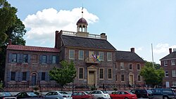
Old New Castle Courthouse.
|
|
 Location in New Castle County and the state of Delaware. |
|
| Location within the state of Delaware | |
| Coordinates: 39°39′43″N 75°33′59″W / 39.66194°N 75.56639°WCoordinates: 39°39′43″N 75°33′59″W / 39.66194°N 75.56639°W | |
| Country | United States |
| State | Delaware |
| County | New Castle |
| Founded | 1640 |
| Area | |
| • Total | 3.2 sq mi (8 km2) |
| • Land | 3.1 sq mi (8 km2) |
| • Water | 0.1 sq mi (0.3 km2) |
| Elevation | 10 ft (3 m) |
| Population (2010) | |
| • Total | 5,285 |
| • Density | 1,594.6/sq mi (615.7/km2) |
| Time zone | Eastern (EST) (UTC-5) |
| • Summer (DST) | EDT (UTC-4) |
| ZIP codes | 19720-19721, 19726 |
| Area code(s) | 302 |
| GNIS feature ID | 214379 |
| Website | New Castle, Delaware |
|
New Castle Historic District
|
|

The Old Arsenal
|
|
| Location | Roughly bounded by the Delaware River, Broad Dike, 4th, 6th,7th, and Penn Sts., New Castle, Delaware |
|---|---|
| Area | 135 acres (55 ha) |
| Built | 1651 |
| Architect | Multiple |
| Architectural style | Colonial, Georgian, Late 19th And 20th Century Revivals, Late Victorian, Federal |
| NRHP Reference # |
67000003 84000312 (increase) |
| Significant dates | |
| Added to NRHP | December 24, 1967 November 08, 1984 |
| Designated NHLD | December 24, 1967 |
New Castle is a city in New Castle County, Delaware, six miles (10 km) south of Wilmington, situated on the Delaware River. In 1900, 3,380 people lived here; in 1910, 3,351. According to the 2010 Census, the population of the city is 5,285.
New Castle was originally settled by the Dutch West India Company in 1651, under the leadership of Peter Stuyvesant, on the site of a former aboriginal village, "Tomakonck" ("Place of the Beaver"), to assert their claim to the area based on a prior agreement with the aboriginal inhabitants of the area. The Dutch originally named the settlement Fort Casimir, but this was changed to Fort Trinity (Swedish: Trefaldighet) following its seizure by the colony of New Sweden on Trinity Sunday, 1654. The Dutch conquered the entire colony of New Sweden the following year and rechristened the fort Nieuw-Amstel ("New Amstel"). This marked the end of the Swedish colony in Delaware as an official entity, but it remained a semi-autonomous unit within the New Netherland colony and the cultural, social, and religious influence of the Swedish settlers remained strong. As the settlement grew, Dutch authorities laid out a grid of streets and established the town common (The "Green"), which continue to this day.
In 1664, the English seized the entire New Netherland colony in the Second Anglo-Dutch War and changed the name of the town to "New Castle." The Dutch regained the town in 1673 during the Third Anglo-Dutch War but it was returned to Great Britain the next year under the Treaty of Westminster. In 1680, New Castle was conveyed to William Penn by the Duke of York by livery of seisin and was Penn's landing place when he first set foot on American soil on October 27, 1682. This transfer to Penn was contested by Lord Baltimore and the boundary dispute was not resolved until the survey conducted by Mason and Dixon, now famed in history as the Mason–Dixon line.
...
Wikipedia


