New Carlisle, Indiana
| New Carlisle, Indiana | |
|---|---|
| Town | |

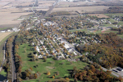
New Carlisle from the air, looking East
|
|
 Location of New Carlisle in the state of Indiana |
|
| Coordinates: 41°42′15″N 86°30′17″W / 41.70417°N 86.50472°WCoordinates: 41°42′15″N 86°30′17″W / 41.70417°N 86.50472°W | |
| Country | United States |
| State | Indiana |
| County | St. Joseph |
| Township | Olive |
| Area | |
| • Total | 2.09 sq mi (5.41 km2) |
| • Land | 2.09 sq mi (5.41 km2) |
| • Water | 0 sq mi (0 km2) |
| Elevation | 810 ft (247 m) |
| Population (2010) | |
| • Total | 1,861 |
| • Estimate (2012) | 1,865 |
| • Density | 890.4/sq mi (343.8/km2) |
| Time zone | Eastern (EST) (UTC-5) |
| • Summer (DST) | EDT (UTC-4) |
| ZIP code | 46552 |
| Area code(s) | 574 |
| FIPS code | 18-52704 |
| GNIS feature ID | 452704 |
New Carlisle is a suburban town in Olive Township, St. Joseph County, in the U.S. state of Indiana. The population was 1,861 at the 2010 Census. It is part of the South Bend–Mishawaka, IN-MI, Metropolitan Statistical Area.
New Carlisle was originally known as Bourissa Hills. This was named after Lazarus Bourissa, a Potawatamie graduate of the Carey Mission who had been granted this section of land by the treaty that moved most of the Potawatamie to the west. It was platted under the name of New Carlisle, by Richard Risley Carlisle, who had come from Philadelphia, in 1835. The New Carlisle post office has been in operation since 1837.
The New Carlisle Historic District and Jeremiah Service House are listed on the National Register of Historic Places.
New Carlisle is located at 41°42′15″N 86°30′17″W / 41.70417°N 86.50472°W (41.704134, -86.504636).
According to the 2010 census, New Carlisle has a total area of 2.08 square miles (5.39 km2), all land.
...
Wikipedia
