Netarhat
|
Netarhat नेतरहाट |
|
|---|---|
| Town | |
 |
|
| Location in Jharkhand, India | |
| Coordinates: 23°29′00″N 84°16′00″E / 23.4833°N 84.2667°ECoordinates: 23°29′00″N 84°16′00″E / 23.4833°N 84.2667°E | |
| Country |
|
| State | Jharkhand |
| District | Latehar |
| Block | Mahuadanar |
| Elevation | 1,071 m (3,514 ft) |
| Languages | |
| • Official | Hindi, Santali |
| Time zone | IST (UTC+5:30) |
| Vehicle registration | JH |
| Website | gumla |
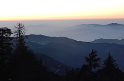
Netarhat is a town in Latehar district(earlier in the erstwhile Palamu district) in the Indian state of Jharkhand. Referred to as the “Queen of Chotanagpur”, it is a popular hill station.
The town is famous for Netarhat Residential School, set up in 1954.
Netarhat is located at 23°29′00″N 84°16′00″E / 23.4833°N 84.2667°E, at a height of 1,071 metres (3,514 ft).
It is a plateau covered with thick forest. Located in the Pat region of Chota Nagpur Plateau, Netarhat plateau is about 4 miles (6.4 km) long and 2.5 miles (4.0 km) broad. It consists of crystalline rocks and has a summit capped with sandstone trap or laterite. The highest point is 3,696 feet (1,127 m)
It is located 156 kilometres (97 mi) west of Ranchi, the state capital. It is 210 kilometres (130 mi) from Daltonganj.
Netarhat is famous for its glorious sunrises and sunsets during the summer months.
Netarhat has several places of tourist interests including Magnolia Point (10 km from Netarhat, ideal site for viewing sunset), Upper Ghaghri Falls (4 km from Netarhat), Lower Ghaghri Falls (10 km from Netarhat), Koel View Point (3 km from Netarhat), Lodh Falls (60 km from Netarhat, the highest waterfall in Jharkhand), Sadni Falls (35 km from Netarhat).
Netarhat Vidyalaya is a residential public school set up in 1954.
...
Wikipedia


