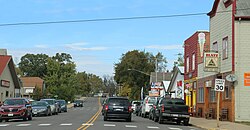
Nelson, Wisconsin
| Nelson, Wisconsin | |
|---|---|
| Village | |

Downtown Nelson
|
|
 |
|
| Coordinates: 44°27′25″N 91°58′26″W / 44.45694°N 91.97389°WCoordinates: 44°27′25″N 91°58′26″W / 44.45694°N 91.97389°W | |
| Country | United States |
| State | Wisconsin |
| County | Buffalo |
| Area | |
| • Total | 1.44 sq mi (3.73 km2) |
| • Land | 1.33 sq mi (3.44 km2) |
| • Water | 0.11 sq mi (0.28 km2) |
| Elevation | 827 ft (252 m) |
| Population (2010) | |
| • Total | 374 |
| • Estimate (2012) | 364 |
| • Density | 281.2/sq mi (108.6/km2) |
| Time zone | Central (CST) (UTC-6) |
| • Summer (DST) | CDT (UTC-5) |
| Area code(s) | 715 & 534 |
| FIPS code | 55-55975 |
| GNIS feature ID | 1583790 |
Nelson is a village in Buffalo County in the U.S. state of Wisconsin. The population was 374 at the 2010 census. The village is surrounded by the Town of Nelson.
Nelson is located at the junction of the Mississippi River and Chippewa River valleys. The river bottoms surrounding the confluence are home to a large amount of wildlife. A causeway and bridge across the Mississippi River link Nelson with the city of Wabasha, Minnesota at the junction of Wisconsin Highway 25 and Wisconsin Highway 35. Southbound Highway 25 becomes Minnesota Highway 60 upon crossing the Mississippi River to Wabasha.
Nelson lies on Wisconsin Highway 35, the "Great River Road," a popular tourist route that runs along the east bank of the Mississippi River. The village's primary destination for tourists is the 100-year-old Nelson Cheese Factory.
Nelson is located at 44°25′22″N 92°0′20″W / 44.42278°N 92.00556°W (44.422799, -92.005812).
According to the United States Census Bureau, the village has a total area of 1.44 square miles (3.73 km2), of which, 1.33 square miles (3.44 km2) of it is land and 0.11 square miles (0.28 km2) is water.
...
Wikipedia
