Neepawa
| Town of Neepawa | |
|---|---|

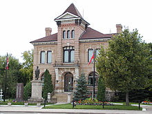
Neepawa Courthouse
|
|
| Location of Neepawa in Manitoba | |
| Coordinates: 50°13′44″N 99°27′56″W / 50.22889°N 99.46556°WCoordinates: 50°13′44″N 99°27′56″W / 50.22889°N 99.46556°W | |
| Country | Canada |
| Province | Manitoba |
| Region | Westman |
| Incorporated | 1883 |
| Government | |
| • Mayor | Adrian de Groot |
| • Town Council | Neepawa Town Council |
| • MLA Agassiz | Eileen Clarke (PC) |
| • MP Dauphin-Swan River-Marquette | Robert Sopuck (PC) |
| Area | |
| • City | 17.57 km2 (6.78 sq mi) |
| Elevation | 358.1 m (1,175 ft) |
| Population (2016) | |
| • City | 4,609 |
| • Density | 206.5/km2 (535/sq mi) |
| • Urban | 3,939 (Population Centre) |
| Time zone | Central (CST) (UTC-6) |
| • Summer (DST) | Central (CDT) (UTC-5) |
| Postal code | R0J 1H0 |
| Area code(s) | 204 |
| Website | neepawa |
Neepawa is a town in Manitoba, Canada located on the Yellowhead Highway at the intersection with Highway 5. As of 2016[update] its population was 4,609. Neepawa was incorporated as a town in 1883. It is located in the Rural Municipality of Langford and bordered to the north by the Rural Municipality of Rosedale. Neepawa is the self-proclaimed Lily capital of the world in part because of its Lily Festival. The town has also been named "Manitoba's Most Beautiful Town", more than any other community in the province.
In the many years before European settlement, the lands around Neepawa were primarily used by the Cree and the Assiniboine. Native peoples in the area followed a regular cycle by following the Plains Bison to take shelter in the areas north of Neepawa in the winter, and then heading south again across the plains and beyond Neepawa in the summer. The town name of Neepawa comes from the Cree word for "Land of Plenty", the name was first used around 1873. Prior to settlement, the only Europeans in the area were primarily fur traders, many people made their way through the area on the North Fort Ellice Trail which went from the Red River to Edmonton. It was on this trail that a group of settlers from Listowel, Ontario eventually decided to settle in 1877, where the Stony and Boggy creeks meet.
The Province of Manitoba was established in 1870, the Neepawa area was in what was then known as "The Northwest Territories", just to the west of the postage stamp province. During the next 30 years, many settlers came to live in the area. The first settlers were from the British Isles. Eastern European settlers also came from countries such as Poland and Hungary and built the Hun Valley Settlement near Neepawa. Neepawa only joined Manitoba when the western edge of the then "postage stamp province" was expanded to its present western borders in 1881.
...
Wikipedia

