Nazarovo, Krasnoyarsk Krai
| Nazarovo Назарово (Russian) |
|
|---|---|
| - Town - | |
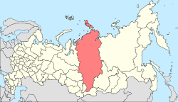
 Location of Krasnoyarsk Krai in Russia |
|
|
|
|
|
|
|
|
|
|
| Administrative status (as of April 2011) | |
| Country | Russia |
| Federal subject | Krasnoyarsk Krai |
| Administratively subordinated to | krai town of Nazarovo |
| Administrative center of | krai town of Nazarovo,Nazarovsky District |
| Municipal status (as of February 2005) | |
| Urban okrug | Nazarovo Urban Okrug |
| Administrative center of | Nazarovo Urban Okrug, Nazarovsky Municipal District |
| Statistics | |
| Population (2010 Census) | 52,817 inhabitants |
| - Rank in 2010 | 309th |
| Time zone | KRAT (UTC+07:00) |
| Founded | 1700 |
| Town status since | 1961 |
| Website | www |
| on | |
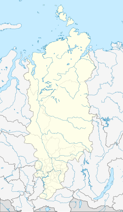
Nazarovo (Russian: Наза́рово) is a town in Krasnoyarsk Krai, Russia, located on the left bank of the Chulym River (Ob's tributary), 239 kilometers (149 mi) west of Krasnoyarsk. Population: 52,817 (2010 Census);56,539 (2002 Census);64,350 (1989 Census).
The selo of Nazarovo was founded in 1700 by Nazary Patyukov, a Cossack, and was named after him. In 1888, deposits of brown coal were discovered in the vicinity of the village, and in 1925 a railroad was built through it. The selo was granted urban-type settlement status in 1946 and town status in 1961.
Within the framework of administrative divisions, Nazarovo serves as the administrative center of Nazarovsky District, even though it is not a part of it. As an administrative division, it is incorporated separately as the krai town of Nazarovo—an administrative unit with the status equal to that of the districts. As a municipal division, the krai town of Nazarovo is incorporated as Nazarovo Urban Okrug.
...
Wikipedia


