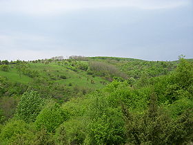
National Park Fruška Gora
| Fruška Gora Фрушка Гора |
|
|---|---|
 |
|
| Highest point | |
| Elevation | 539 m (1,768 ft) |
| Coordinates | 45°09′04″N 19°42′40″E / 45.1511°N 19.7111°ECoordinates: 45°09′04″N 19°42′40″E / 45.1511°N 19.7111°E |
| Geography | |
| Location | Syrmia / Serbia |
| Parent range | Pannonian island mountains |
| Geology | |
| Mountain type | Island mountain |
|
IUCN category II (national park)
|
|

Fruška Gora National Park
|
|
| Area | 266.72 km2 (102.98 sq mi) |
| Established | 1960 |
Fruška Gora is a mountain in north Srem. Most of it is located within the Syrmia region, Serbia, but a smaller part on its western side overlaps the territory of Croatia. Sometimes, it is also referred to as jewel of Serbia, due to its beautiful landscape protection area, nature and its picturesque countryside.
In Serbian, it is known as Fruška gora (pronounced [frûʃkaː ɡǒra], Фрушка гора), in Hungarian as Tarcal (also Almus-hegy or Árpatarló), in German as Frankenwald, and in Latin as Alma Mons. In Medieval Greek, it was known as Frangochoria.
The mountain's name originates in the old Serbian word "Fruzi" of which singular form is "Frug"; and its adjective is Fruški, which was used for naming the Frankish people. The name of "Fruška Gora" is "Frankish mountain" in English whose meaning is based on describing a historical event, viz, the mountain served as a natural border when Frankish campaigns were set up in the area.
In the time of the Roman Empire, its name was Alma Mons, meaning the "fertile mount". It is recorded that during the reign of the emperor Marcus Aurelius Probus, 276-282, who was born in the nearby Sirmium, first grapevines were planted on the mountain.
The mountain is a natural geological phenomenon as it is built from the rocks from almost all geological periods. It used to be an island during the existence of the Pannonian Sea. To the north, the mountain is bordered by the Danube river, while to the south it descends into the Syrmian lowlands. Lengthwise, it is approximately 80 km (50 mi) from east to west and is 15 km (9.3 mi) from north to south. Its highest peak is Crveni Čot at 539 m (1,768 ft).
...
Wikipedia

