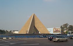
Nasr City
|
Nasr City مدينة نصر |
|
|---|---|
 |
|
| Coordinates: 30°03′N 31°22′E / 30.050°N 31.367°ECoordinates: 30°03′N 31°22′E / 30.050°N 31.367°E | |
| Government | |
| • City Leader | Major General. Mohamed El-Sheikh |
| Area | |
| • Total | 250 km2 (100 sq mi) |
| Time zone | EET (UTC+2) |
Nasr City (Arabic: مدينة نصر pronounced [mæˈdiːnɪt ˈnɑsˤɾ]) is a district of Cairo, Egypt. It is located to the east of the Cairo Governorate and consists mostly of condominia. It was established in the 1960s as an extension to neighboring settlement of Heliopolis. The establishment of the district was part of the Egyptian Government's plan to modernise and expand Cairo following the Egyptian Revolution of 1952. Gamal Abdel Nasser, the Egyptian President at the time, was involved personally in the design process, and was the one who chose the name Nasr for the new district ("nasr" being the Arabic word for "victory"). During the early stages of the project it was envisioned that it would constitute a new capital city. Now, Nasr City is extremely crowded, much more than was expected from the creation of the district, because of Egyptian families relocating to the district and also because of Somali and Sudanese immigration to areas of Nasr City such as Hay El Asher (10th Neighbourhood).
It is the largest district in Cairo, occupying nearly 250 km² of the capital's total area of 1,445 km². For this reason, it is divided into 10 sub-districts, of which numbers 6-10 are called by their respective numbers and the first 5 are called by their names. It has a modern road system, and grid street system, which stands in contrast to the narrow winding streets of much of Old Cairo. Tram system partly serve Nasr City. Also, other forms of transportation exist in Nasr City, including minibuses, microbuses (share taxis), and tuk-tuks (in the 10th district of Nasr City).
...
Wikipedia
