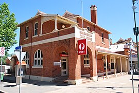
Narrandera, New South Wales
|
Narrandera New South Wales |
|||||||
|---|---|---|---|---|---|---|---|

Narrandera Post Office
|
|||||||
| Coordinates | 34°45′0″S 146°33′0″E / 34.75000°S 146.55000°ECoordinates: 34°45′0″S 146°33′0″E / 34.75000°S 146.55000°E | ||||||
| Population | 3,871 (2011 census) | ||||||
| Postcode(s) | 2700 | ||||||
| Elevation | 173.0 m (568 ft) | ||||||
| Location |
|
||||||
| LGA(s) | Narrandera Shire | ||||||
| County | Cooper | ||||||
| State electorate(s) | Cootamundra | ||||||
| Federal Division(s) | Farrer | ||||||
|
|||||||
Narrandera (/nəˈrændərə/ nə-RAN-dər-ə) until around 1949 also spelled "Narandera", is a town located in the Riverina region of southern New South Wales, Australia. The town lies on the junction of the Newell and Sturt highways, adjacent to the Murrumbidgee River, and it is the gateway to the Murrumbidgee Irrigation Area. At the 2011 census, Narrandera had a population of 3,871 people.
Narrandera is a river town with a rich heritage. Captain Charles Sturt is credited with being the first European to observe the area that later was to become known as Narrandera. However Sturt, who passed through the district on 12 December 1829, was not the first explorer to cast eyes on the Murrumbidgee River. The upper Murrumbidgee, the "Big Water", was first discovered in April 1821, by Charles Throsby. The name Narrandera is probably derived from Wiradjuri nharrang, meaning "frill-necked lizard".
The local indigenous people were all but destroyed by settlement, disease brought by European settlers, and clashes with the settlers. The last major battle between the indigenous people and European settlers took place near Massacre Island, and is said to have left only one survivor.
...
Wikipedia

