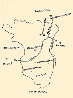
Narasapuram mandal, West Godavari district
|
Narasapuram mandal నరసాపురం మండలం |
|
|---|---|
| Mandal | |

Narasapuram mandal map
|
|
| Location in Andhra Pradesh, India | |
| Coordinates: 16°26′N 81°41′E / 16.433°N 81.683°ECoordinates: 16°26′N 81°41′E / 16.433°N 81.683°E | |
| Country | India |
| State | Andhra Pradesh |
| District | West Godavari |
| Headquarters | Narasapuram |
| Government | |
| • Body | Mandal Parishad |
| Area | |
| • Total | 153.65 km2 (59.32 sq mi) |
| Population (2011) | |
| • Total | 79,971 |
| • Density | 520/km2 (1,300/sq mi) |
| Languages | |
| • Official | Telugu |
| Time zone | IST (UTC+5:30) |
Narasapuram mandal is one of the 48 mandals in West Godavari district of the Indian state of Andhra Pradesh. It is under the administration of Narasapuram revenue division and the headquarters are located at Narasapuram. The mandal is located on the banks of Vasista river, a tributary of Godavari river, which empties into Bay of Bengal at southern part of the mandal and bounded by Veeravasaram, Palakollu, Yelamanchili, Mogalthur, Bhimavaram mandals.
As of 2011[update]census of India, the mandal has 36 settlements, which includes 1 towns and 35 villages. Narasapuram is the only town in the mandal.
The settlements in the mandal are listed below:
...
Wikipedia

