Napeague
| Napeague, New York | |
|---|---|
| Hamlet and census-designated place | |

Mackay Tower and Art Barge
|
|
 |
|
| Coordinates: 40°59′42″N 72°4′30″W / 40.99500°N 72.07500°WCoordinates: 40°59′42″N 72°4′30″W / 40.99500°N 72.07500°W | |
| Country | United States |
| State | New York |
| County | Suffolk |
| Town | East Hampton |
| Area | |
| • Total | 3.7 sq mi (9.7 km2) |
| • Land | 3.7 sq mi (9.5 km2) |
| • Water | 0.08 sq mi (0.2 km2) |
| Elevation | 7 ft (2 m) |
| Population (2010) | |
| • Total | 200 |
| • Density | 53/sq mi (21/km2) |
| Time zone | Eastern (EST) (UTC-5) |
| • Summer (DST) | EDT (UTC-4) |
| FIPS code | 36-49424 |
| GNIS feature ID | 0958252 |
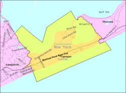
Napeague (/ˈnæpiːɡ/, NAP-eeg) is a census-designated place (CDP) that roughly corresponds to the hamlet with the same name in the Town of East Hampton in Suffolk County, New York, United States. The CDP population was 200 at the 2010 census.
Napeague is located on a very narrow, low-lying strip between the Atlantic Ocean to the south and Gardiners Bay to the north that was flooded in the Great Hurricane of 1938. It lies between Napeague State Park on the west and Hither Hills State Park on the east.
Napeague derives its name from the Montaukett name for "land overflowed by the sea".
The hamlet's three major landmarks are the Mackay Radio Tower, the Art Barge, and the Smith Meal Fish Factory.
The Mackay Radio Tower is the last of two towers (originally 300 feet (91 m) high and 1,000 feet (300 m) apart) that were used to transmit international point-to-point radio communications starting in 1927. At the height of World War II the tower was used for responding to upwards of ten SOS calls a day from ships at sea. The tower had somebody on site 24 hours a day, but the actual transmissions were keyed from Southampton. The towers toppled during the Great 1938 Hurricane.
...
Wikipedia

