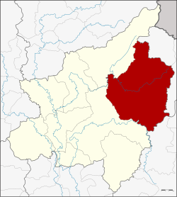
Nakhon Thai District
|
Nakhon Thai นครไทย |
|
|---|---|
| Amphoe | |
 Amphoe location in Phitsanulok Province |
|
| Coordinates: 17°6′3″N 100°50′16″E / 17.10083°N 100.83778°ECoordinates: 17°6′3″N 100°50′16″E / 17.10083°N 100.83778°E | |
| Country |
|
| Province | Phitsanulok |
| Tambon | 11 |
| Muban | 145 |
| Area | |
| • Total | 2,220.374 km2 (857.291 sq mi) |
| Population (2013) | |
| • Total | 86,684 |
| • Density | 38.7/km2 (100/sq mi) |
| Time zone | THA (UTC+7) |
| Postal code | 65120 |
| Geocode | 6502 |
Nakhon Thai (Thai: นครไทย) is a district (amphoe) in the eastern part of Phitsanulok Province, northern Thailand.
Neighboring districts are (from the southwest clockwise) Wang Thong, Chat Trakan of Phitsanulok Province, Na Haeo, Dan Sai of Loei Province and Khao Kho of Phetchabun Province.
The Phu Hin Rong Kla National Park is located in Nakhon Thai district.
Nakhon Thai lies within the Nan Basin, which is part of the Chao Phraya Watershed. The Khwae Noi River flows through the district, as well as the lesser Fia (Thai: ลำน้ำเฟี้ย) and Kaem (Thai: ลำน้ำแขม) Rivers.
The district Nakhon Thai is subdivided into 11 subdistricts (Tambon), which are further subdivided into 145 administrative villages (Muban).
There are 2 subdistrict municipalities (Thesaban Tambon) in the district:
There are 9 subdistrict administrative organizations (SAO) in the district:
There are 23 Buddhist temples in Amphoe Nakhon Thai.
...
Wikipedia
