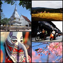
Loei Province
|
Loei เลย |
||
|---|---|---|
| Province | ||
 |
||
|
||
| Motto: City of the sea of mountains, coldest place in Siam, with beautiful flowers of three seasons | ||
 Map of Thailand highlighting Loei Province |
||
| Coordinates: 17°29′12″N 101°43′10″E / 17.48667°N 101.71944°ECoordinates: 17°29′12″N 101°43′10″E / 17.48667°N 101.71944°E | ||
| Country | Thailand | |
| Capital | Loei town | |
| Government | ||
| • Governor | Khumphon Banthaothuk (since October 2016) | |
| Area | ||
| • Total | 11,424.6 km2 (4,411.1 sq mi) | |
| Area rank | Ranked 14th | |
| Population (2014) | ||
| • Total | 634,513 | |
| • Rank | Ranked 40th | |
| • Density | 55.33/km2 (143.3/sq mi) | |
| • Density rank | Ranked 72nd | |
| HDI | ||
| • HDI (2009) | 0.731 (42nd) | |
| Time zone | ICT (UTC+7) | |
| Area code(s) | 042 | |
| ISO 3166 code | TH-42 | |
| Vehicle registration | เลย | |
| Website | www |
|
Loei (Thai: , pronounced [lɤ̄ːj]), in Isan, is one of the most sparsely populated provinces (changwat) of Thailand. Neighboring provinces are (from east clockwise) Nong Khai, Udon Thani, Nongbua Lamphu, Khon Kaen, Phetchabun, Phitsanulok. In the north it borders Xaignabouli and Vientiane Province of Laos.
The city of Loei is surrounded by mountain ranges whose summits are covered by fog and abundant with varied flora. The best known mountains in the province are Phu Kradueng, Phu Luang, and Phu Ruea.
The province is dotted with mountains, such as Phu Kradueng and Phu Ruea, while the seat of provincial government, Loei, is in a fertile basin. The Loei River, which flows through the province, is a tributary of the Mekong, which forms part of the northern boundary of the province with neighboring Laos. Phu Thap Buek, the highest mountain of the Phetchabun Range, is in the province.
The mountain of Phu Kradueng is part of the Phu Kradueng National Park. Other national parks include Phu Hin Rong Kla, Phu Ruea, Phu Pha Man, and Phu Suan Sai (also known as Na Haeo).
...
Wikipedia

