Nakhon Ratchasima Province
|
Nakhon Ratchasima นครราชสีมา |
||
|---|---|---|
| Province | ||
| Nakhon Ratchasima Province | ||

Statue of Lady Mo in Khorat city centre
|
||
|
||
| Nickname(s): Khorat | ||
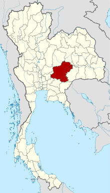
 Map of Thailand highlighting Nakhon Ratchasima Province |
||
| Country | Thailand | |
| Capital | Nakhon Ratchasima City | |
| Government | ||
| • Governor | Wichian Chanthranothai (since October 2015) | |
| Area | ||
| • Total | 20,494 km2 (7,913 sq mi) | |
| Area rank | Ranked 1st | |
| Population (2014) | ||
| • Total | 2,620,517 | |
| • Rank | Ranked 2nd | |
| • Density rank | Ranked 34th | |
| Time zone | ICT (UTC+7) | |
| ISO 3166 code | TH-30 | |
| Website | www.nakhonratchasima.go.th | |
Nakhon Ratchasima (Thai: นครราชสีมา), often called Korat (Thai: โคราช; rtgs: Khorat), is one of the Isan provinces (changwat) of Thailand's northeast corner. It is the country's largest province by area, with a population of about 2.7 million who produce about 250 billion baht in GDP, the highest in Isan. Neighbouring provinces are (clockwise, from north) Chaiyaphum, Khon Kaen, Buriram, Sa Kaeo, Prachinburi, Nakhon Nayok, Saraburi, and Lopburi.
The capital of the province is the city of Nakhon Ratchasima in Mueang Nakhon Ratchasima District, also called Korat or Khorat.
The province is at the west end of the Khorat Plateau, separated from the Chao Phraya river valley by the Phetchabun and Dong Phaya Yen mountain ranges. Two national parks are in the province: Khao Yai in the west and Thap Lan in the south. Both parks are in the forested mountains of the Sankamphaeng Range, the southern prolongation of the Dong Phaya Yen mountains
...
Wikipedia

