Sankamphaeng Range
| Sankamphaeng Range | |
|---|---|
| ทิวเขาสันกำแพง | |

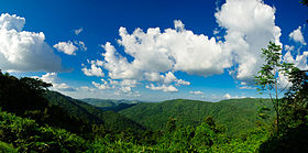
View of the forested mountains of the Sankamphaeng Range in the Khao Yai National Park area
|
|
| Highest point | |
| Peak | Khao Rom |
| Elevation | 1,351 m (4,432 ft) |
| Dimensions | |
| Length | 180 km (110 mi) E/W |
| Width | 40 km (25 mi) N/S |
| Geography | |
| Country | Thailand |
| States/Provinces | |
| Range coordinates | 14°26′N 101°23′E / 14.44°N 101.38°ECoordinates: 14°26′N 101°23′E / 14.44°N 101.38°E |
| Borders on | Dong Phaya Yen Mountains and Dângrêk Mountains |
| Geology | |
| Type of rock | Sandstone, conglomerate |
The Sankamphaeng Range, also Sankambeng Range or Sungumpang Range (Thai: ทิวเขาสันกำแพง, rtgs: Thio Khao San Kamphaeng, Thai pronunciation: [tʰiw kʰǎw sǎn kampʰɛːŋ]) is one of the mountain ranges separating eastern Thailand from the northeast or Isan. It is in Nakhon Nayok, Prachinburi, Sa Kaeo, Saraburi, and Nakhon Ratchasima Provinces, Thailand.
The meaning of the word Sankamphaeng in the Thai language is fortification or counterfort. It is a fitting name to describe this mountain range that effectively constituted a natural buttress between the Khorat Plateau and the plain of Central Thailand.
The mountain chain runs in a WNW-ESE direction. The northern part of the Sankamphaeng mountain range merges with the southern end of the Dong Phaya Yen Mountains, which run roughly in a north-south direction at the southwestern boundary of the Khorat Plateau.
To the east this range connects with the Dângrêk Mountains, a longer system running in an east-west direction that stretches into Laos. The southern mountainsides of the range drain into the Prachinburi River.
...
Wikipedia

