Buriram Province
|
Buriram บุรีรัมย์ |
||
|---|---|---|
| Province | ||

|
||
|
||
 Map of Thailand highlighting Buriram Province |
||
| Country | Thailand | |
| Capital | Buriram | |
| Government | ||
| • Governor | Anuson Kaeokangwan (since October 2016) | |
| Area | ||
| • Total | 10,322.9 km2 (3,985.7 sq mi) | |
| Area rank | Ranked 17th | |
| Population (2014) | ||
| • Total | 1,579,248 | |
| • Rank | Ranked 5th | |
| • Density rank | Ranked 27th | |
| HDI | ||
| • HDI (2009) | 0.729 (medium) (45th) | |
| Time zone | ICT (UTC+7) | |
| Area code(s) | 044 | |
| ISO 3166 code | TH-31 | |
| Vehicle registration | บุรีรัมย์ | |
Buriram (Thai: บุรีรัมย์, rtgs: Buri Ram, pronounced [bū.rīː rām]) is one of the northeastern provinces (changwat) of Thailand. Neighboring provinces are (from south clockwise) Sa Kaeo, Nakhon Ratchasima, Khon Kaen, Maha Sarakham, and Surin. To the southeast it borders Oddar Meancheay of Cambodia. The name Buriram means city of happiness.
Buriram is at the south end of the Khorat Plateau, with several extinct volcanoes around the province. The southern limit of the province is a mountainous area at the limit between the Sankamphaeng Range and the Dângrêk Mountains.
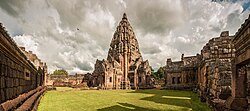
About a thousand years ago, the area that makes up today's Buriram Province was under the Khmer Empire and many ruins remain from that time. The largest, standing on an extinct volcano, is in the Phanom Rung historical park. According to an inscription found there, its local ruler recognised the authority of the Khmer king. However, the area was remote and sparsely populated, and little is recorded about it until the Bangkok Period of Thai history. In the early nineteenth century, Muang Pae, the largest town, acknowledged Thai sovereignty and was renamed Buriram. Following administrative reforms in the late nineteenth century, Buriram was formally incorporated into Thailand as a province with its own governor.
...
Wikipedia

