Muscogee County
| Muscogee County, Georgia | |
|---|---|
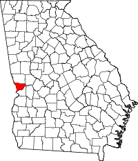
 Location in the U.S. state of Georgia |
|
 Georgia's location in the U.S. |
|
| Founded | June 9, 1826 |
| Named for | Muscogee people |
| Seat | Columbus |
| Largest city | Columbus |
| Area | |
| • Total | 221 sq mi (572 km2) |
| • Land | 216 sq mi (559 km2) |
| • Water | 4.6 sq mi (12 km2), 2.1% |
| Population (est.) | |
| • (2015) | 200,579 |
| • Density | 878/sq mi (339/km²) |
| Congressional districts | 2nd, 3rd |
| Time zone | Eastern: UTC-5/-4 |
| Website | www |
Muscogee County is a county located on the central western border of the U.S. state of Georgia; its western border with the state of Alabama is formed by the Chattahoochee River. As of the 2010 census, the population was 189,885. Its county seat and only city is Columbus, with which it has been a consolidated city-county since the beginning of 1971.
Muscogee County is part of Columbus, GA-AL Metropolitan Statistical Area.
The only other city in the county was Bibb City, a company town that disincorporated in December 2000, two years after its mill closed permanently. Fort Benning, a large Army installation, takes up nearly one quarter of the county and extends into Chattahoochee County; it generates considerable economic power in the region.
Inhabited for thousands of years by varying cultures of indigenous peoples, this area was territory of the historic Creek people at the time of European encounter.
The land for Lee, Muscogee, Troup, Coweta, and Carroll counties was ceded by a certain eight chiefs among the Creek people in the 1825 Treaty of Indian Springs. The Creek Nation declared the land cession illegal, because it did not represent the will of the majority of the people. The United States Senate did not ratify it. The following year, the US government negotiated another treaty with the Creek, by which they ceded nearly as much territory under continued pressure from the state of Georgia and US land commissioners.
...
Wikipedia
