Murrells Inlet, South Carolina
| Murrells Inlet, South Carolina | |
|---|---|
| Census-designated place | |
 |
|
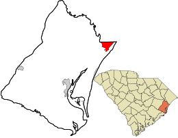
 Location in Georgetown County and the state of South Carolina |
|
| Coordinates: 33°33′6″N 79°2′56″W / 33.55167°N 79.04889°WCoordinates: 33°33′6″N 79°2′56″W / 33.55167°N 79.04889°W | |
| Country | United States |
| State | South Carolina |
| County | Georgetown |
| Area | |
| • Total | 7.5 sq mi (19.5 km2) |
| • Land | 7.4 sq mi (19.1 km2) |
| • Water | 0.2 sq mi (0.4 km2) |
| Elevation | 3 ft (0.9 m) |
| Population (2010) | |
| • Total | 7,547 |
| • Density | 1,025/sq mi (395.9/km2) |
| Time zone | EST (UTC-5) |
| • Summer (DST) | EDT (UTC-4) |
| ZIP Code | 29576 |
| FIPS code | 45-48985 |
| GNIS feature ID | 1253479 |
Murrells Inlet is an unincorporated area and census-designated place in Georgetown County, South Carolina, United States. The population was 7,547 at the 2010 census. The community was once primarily a fishing village, but has grown substantially in modern time, along with the rest of the Grand Strand, into a popular tourist and retirement location. It is most known for the Murrells Inlet Marshwalk, a 1⁄2-mile-long (0.8 km) boardwalk overlooking a salt marsh and which houses many restaurants.
Murrells Inlet is located in northeastern Georgetown County at 33°33′6″N 79°2′56″W / 33.55167°N 79.04889°W (33.551593, -79.048794). The northern edge of the CDP follows the Horry County line. U.S. Route 17 (Ocean Highway) runs through the center of the community, leading northeast 13 miles (21 km) to Myrtle Beach and southwest 21 miles (34 km) to Georgetown, the seat of Georgetown County.
According to the United States Census Bureau, the Murrells Inlet CDP has a total area of 7.5 square miles (19.5 km2), of which 7.4 square miles (19.1 km2) are land and 0.2 square miles (0.4 km2), or 2.21%, are water.
...
Wikipedia
