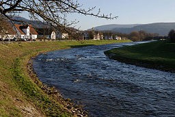
Murg (Northern Black Forest)
| Murg | |
| River | |
|
The river Murg at Gaggenau-Hörden
|
|
| Country | Germany |
|---|---|
| State | Baden-Württemberg |
| Tributaries | |
| - left | Tonbach, Schönmünz, Raumünzach, Oos River (North channel) |
| - right | Forbach |
| Source | Murgursprung |
| - elevation | 875 m (2,871 ft) |
| Source confluence | Rechtmurg and Rotmurg |
| - location | Obertal, Baiersbronn, Freudenstadt District |
| - elevation | 602 m (1,975 ft) |
| - coordinates | 48°31′57″N 08°17′18.5″E / 48.53250°N 8.288472°E |
| Mouth | Rhine |
| - location | Steinmauern, Rastatt District |
| - elevation | 110 m (361 ft) |
| - coordinates | 48°55′08″N 08°09′54″E / 48.91889°N 8.16500°ECoordinates: 48°55′08″N 08°09′54″E / 48.91889°N 8.16500°E |
| Length | 79.267 km (49 mi) |
| Basin | 617 km2 (238 sq mi) |
| Discharge | |
| - average | 18.44 m3/s (651 cu ft/s) |
The Murg is an 80.2-kilometre-long river (including its headstream, the Rechtmurg) and a right tributary of the Rhine in Baden-Württemberg, Germany. It flows through the Northern Black Forest into the Upper Rhine Plain, crossing the counties of Freudenstadt and Rastatt.
The river has numerous tributaries and is known as the Murg only from the point of confluence of the rivers Rechtmurg ("Right Murg") and Rotmurg ("Red Murg") in the community of Obertal, a part (Ortsteil) of Baiersbronn. The main source river is the Rechtmurg that rises on the Schliffkopf hill at an elevation of 875 metres (2,871 ft). One of the other many tributaries is called Murgursprung ("Source of the Murg"), but the tributary watercourses have lengths that vary with rainfall. The Rotmurg also has many tributaries, the most important of which rises on the Ruhestein hill near Baiersbronn. The length figure of 79.267 kilometres (49.254 mi) given by the Ministry of the Environment for Baden-Württemberg should, as a result, be taken as an approximate figure.
From the confluence of the Rotmurg and Rechtmurg, the Murg flows east to Baiersbronn, then north through Forbach, Gernsbach and Gaggenau. It then turns northwest through Rastatt and reaches the Rhine at kilometre 344.5 at the community of Steinmauern.
The Murg flows through one of the largest valleys of the Black Forest, the Murg Valley in the west of the Northern Black Forest, then through the Upper Rhine Plain, primarily north and northwest. Its drainage basin covers 617 square kilometres (238 sq mi).
...
Wikipedia


