Mukhalingam
|
Mukhalingam ముఖలింగం Srimukhalingam |
|
|---|---|
| Village | |

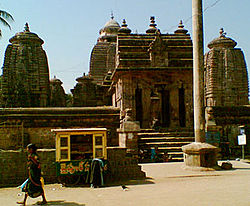
Srimukhalingam temple
|
|
| Location in Andhra Pradesh, India | |
| Coordinates: 18°36′00″N 83°58′00″E / 18.6000°N 83.9667°ECoordinates: 18°36′00″N 83°58′00″E / 18.6000°N 83.9667°E | |
| Country |
|
| State | Andhra Pradesh |
| District | Srikakulam |
| Talukas | Jalumuru |
| Population | |
| • Total | 3,204 |
| Languages | |
| • Official | Telugu |
| Time zone | IST (UTC+5:30) |
| PIN | 532428 |
| Vehicle registration | AP 30 |
Mukhalingam is a village panchayat in Jalumuru mandal of Srikakulam district, Andhra Pradesh, India.
Mukhalingam is located at 18°35′39″N 83°57′49″E / 18.5943°N 83.9635°E. It has an average elevation of 28 metres (92 ft).
According to the 2011 Census of India, the demographic details of Mukhalingam are as follows:
The Srimukhalingeswara temple is a Shiva temple in the village, which was built by Kamarnava–II in 8th century AD of the Eastern Ganga dynasty. Every year famous Chakratitha snanam(holy bath) is taken by pilgrims . Lakhs of pilgrims visit from Odisha and Andhra Pradesh on the auspicious day to take the holy bath and take blessings of Lord Shiva.
A relief of Trimurti on a dome at Sri Mukhalingam temple complex
View of a dome at Sri Mukhalingam Temple complex
A relief carved out on walls for a drain at Sri Mukhalingam Temple
...
Wikipedia


