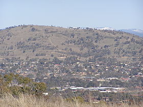
Mt Taylor, Australian Capital Territory
| Mount Taylor | |
|---|---|

Mount Taylor viewed from Red Hill.
|
|
| Highest point | |
| Elevation | 856 m (2,808 ft) |
| Coordinates | 35°22′19″S 149°04′22″E / 35.37194°S 149.07278°ECoordinates: 35°22′19″S 149°04′22″E / 35.37194°S 149.07278°E |
| Geography | |
| Location | Australian Capital Territory, Australia |
Mount Taylor is a prominent hill with an elevation of 856 metres (2,808 ft) AHD that is located between the Woden Valley, Weston Creek district and Tuggeranong Valley, in Canberra, within the Australian Capital Territory, Australia. Mount Taylor is part of the Canberra Nature Park and is surrounded by the suburbs of Kambah, Fisher, Waramanga, Chifley, Pearce, and Torrens. There are walking tracks to the peak. While there is no public road access to the peak there is a fire trail up the mountain from the end of Waldock St, Chifley where there is also a car park and picnic tables. The fire trail (also known as the management trail) is normally closed to public vehicular access by locked gates, but the gates contain access points for walkers. The trail is especially popular with families and older walkers as it provides the easiest and most leisurely access to the peak. Originally a dirt road, it was partially sealed in 2009 on the steeper grades to make it safer for walkers and mountain bike riders.
From the Tuggeranong (Kambah) side there is a popular foot trail up the mountain that can be accessed from an unsealed car parking area off Sulwood Drive. It is potholed and unsafe and numerous car accidents have occurred. This foot track up the mountain can also be accessed from Gouger St, Torrens. Unlike the fire trail, this is a properly constructed reinforced footpath, concrete mostly but packed clay and fine, compacted gravel in other places. This track is longer and generally steeper than the fire trail making it especially popular among fitness enthusiasts who incorporate running up and down the track into their training routines. Dog owners also use the track to exercise their pets. Part of the track follows the 750m contour line and there are rest benches along the way. It is very picturesque, passing through a heavily treed area near the summit and there are steps in this vicinity due to the steepness. Near the summit, the foot track from Tuggeranong merges into the sealed fire trail coming from the Woden side.
...
Wikipedia

