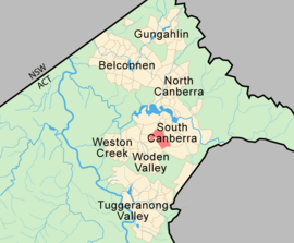
Red Hill, Australian Capital Territory
|
Red Hill Canberra, Australian Capital Territory |
|||||||||||||
|---|---|---|---|---|---|---|---|---|---|---|---|---|---|
 |
|||||||||||||
| Coordinates | 35°19′59″S 149°07′59″E / 35.333°S 149.133°ECoordinates: 35°19′59″S 149°07′59″E / 35.333°S 149.133°E | ||||||||||||
| Population | 3,249 (2011 census) | ||||||||||||
| • Density | 645/km2 (1,670/sq mi) | ||||||||||||
| Established | 1928 | ||||||||||||
| Gazetted | 20 September 1928 | ||||||||||||
| Postcode(s) | 2603 | ||||||||||||
| Area | 4.87 km2 (1.9 sq mi) | ||||||||||||
| District | South Canberra | ||||||||||||
| Territory electorate(s) | Kurrajong | ||||||||||||
| Federal Division(s) | Canberra | ||||||||||||
|
|||||||||||||
Red Hill (postcode: 2603) is a suburb of Canberra, Australian Capital Territory, Australia. The suburb is named after the northernmost hill of the ridge to the west of the suburb. The ridge is a reserve and managed as part of the Canberra Nature Park. The hill is an element of the central Canberra design axis.
The name 'Red Hill' was gazetted as a suburb name in 1928. This was the name associated with the hill since the days of the early settlers and probably suggested by the red soil in the area. Streets are named after ships and explorers. Mugga Way is named after an Aboriginal word also associated with the locality since the days of the early settlers.
The hill was once part of the Narrabundah lease held by Charles Russell. He grazed sheep but as the suburb became built up, local pet dogs worried them and killed them. He changed to cattle and finally gave up the lease in 1992.
The Red Hill Precinct or "Old Red Hill" is bounded by Mugga Way, Moresby Street, Arthur Circle, Monaro Crescent and Flinders Way. The major streets of this area were included in an outline plan for the early development of Canberra prepared by Walter Burley Griffin in 1918. Its streetscape and landscape character reflect 1920s garden city planning. It is listed by the ACT Heritage Council.
Residential land in the suburb of Red Hill was offered for sale in the first Canberra land auction conducted on 12 December 1924. By 1929, 22 houses had been built and by 1955 there were 64 houses.
Other sites in Red Hill listed by the ACT Heritage Council are:
Red Hill's most important recreational area is the hill itself. From the Canberra Times Letters to the Editor in May 2000 one resident said:
Red Hill has a local public primary school and a government pre school located in the same building complex. The Red Hill School is an accredited IB World School. There is also a Catholic primary school, St Bede's Primary School, and the Canberra Grammar School, an Anglican school for boys and girls, and a French-Australian preschool.
Red Hill residents get preference for:
Calthorpes' House at 24 Mugga Way was built in 1927 by Harry Calthorpe, stock and station agent with the firm Woodgers & Calthorpe. Designed by the architectural firm of Oakley and Parkes, the house displays many characteristics of the Spanish Mission style. The family (Harry, his wife Del and two daughters, Del and Dawn) lived together in the house throughout the Depression and Second World War, when both girls married. After Harry's death in 1950, his wife continued to live in the house, mostly alone. While friends and neighbours redecorated their houses, she elder never did. After her death in 1979, it was recognised that an opportunity existed to preserve a house that related to Canberra's early years in staggering completeness, and the Australian Commonwealth Government bought the house, its garden and the house's contents from the two daughters in 1984.
...
Wikipedia
