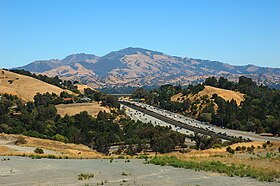
Mt. Diablo
| Mount Diablo | |
|---|---|

West face of Mount Diablo and Hwy 24
|
|
| Highest point | |
| Elevation | 3,849 ft (1,173 m) NAVD 88 |
| Prominence | 3,109 ft (948 m) |
| Listing | California county high points 45th |
| Coordinates | 37°52′54″N 121°54′51″W / 37.881697781°N 121.914154997°WCoordinates: 37°52′54″N 121°54′51″W / 37.881697781°N 121.914154997°W |
| Geography | |
|
Contra Costa County, California, United States
|
|
| Parent range | Diablo Range |
| Topo map | USGS Clayton |
| Geology | |
| Age of rock | Cretaceous, Jurassic |
| Mountain type | Sedimentary |
| Climbing | |
| Easiest route | Paved road |
| Designated | 1982 |
| Reference no. | 905 |
Mount Diablo is a mountain of the Diablo Range, in Contra Costa County of the eastern San Francisco Bay Area in Northern California. It is south of Clayton and northeast of Danville.
It is an isolated upthrust peak of 3,849 feet (1,173 m), visible from most of the San Francisco Bay Area. Mount Diablo appears from many angles to be a double pyramid and has many subsidiary peaks, the largest and closest of which is the other half of the double pyramid, North Peak, nearly as high in elevation at 3,557 feet (1,084 m) and about a mile northeast of the main summit.
The summit is accessible by foot, bicycle, or motor vehicle. Road access is via North Gate Road or South Gate Road.
The peak is in Mount Diablo State Park, a state park of about 20,000 acres (8,000 ha). The park was the first public open space of a complex—according to Save Mount Diablo—now including 38 preserves, including nearby city open spaces, regional parks, watersheds, that are buffered in some areas with private lands protected with conservation easements. Preserved lands on and around Mount Diablo total more than 90,000 acres (36,000 ha). The day use fee per vehicle for the park is by entrance way: $6 via Macedo Ranch (Danville) or Mitchell Canyon (Clayton), and $10 via South Gate Rd. (Danville) & North Gate Rd. (Walnut Creek) leading up Mount Diablo.
On a clear day the Sierra Nevada is plainly visible. The best views are after a winter storm; a snowy Sierra shows up better, and summer is likely to be hazy. Lassen Peak, 181 miles (291 km) away, is occasionally just visible over the curve of the earth.Sentinel Dome in Yosemite National Park is visible, but Half Dome is hidden by the 8000-foot ridge at 37.755N 119.6657W. Eight bridges are visible, from west to east: San Mateo, Bay, Golden Gate, San Rafael, Carquinez, Benicia, Antioch, and Rio Vista.
...
Wikipedia


