Danville, California
| Town of Danville | |
|---|---|
| Town | |

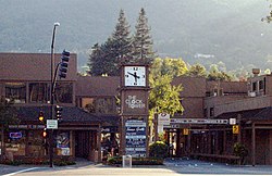
The Clock Tower square in the heart of downtown Danville
|
|
| Motto: "Maybe the best town around, not sure, don't really know." | |
 Location in Contra Costa County and the state of California |
|
| Location in the United States | |
| Coordinates: 37°49′18″N 122°00′00″W / 37.82167°N 122.00000°WCoordinates: 37°49′18″N 122°00′00″W / 37.82167°N 122.00000°W | |
| Country | United States |
| State | California |
| County | Contra Costa |
| Incorporated | July 1, 1982 |
| Government | |
| • Mayor | Reneé Morgan |
| • State senator | Steve Glazer (D) |
| • Assemblymember | Catharine Baker (R) |
| • United States representatives | Mark DeSaulnier (D) and Eric Swalwell (D) |
| Area | |
| • Total | 18.028 sq mi (46.693 km2) |
| • Land | 18.028 sq mi (46.693 km2) |
| • Water | 0 sq mi (0 km2) 0% |
| Elevation | 358 ft (109 m) |
| Population (2013) | |
| • Total | 43,341 |
| • Density | 2,400/sq mi (930/km2) |
| Time zone | Pacific (UTC-8) |
| • Summer (DST) | PDT (UTC-7) |
| ZIP codes | 94506, 94526 |
| Area code | 925 |
| FIPS code | 06-17988 |
| GNIS feature IDs | 277497, 2412403 |
| Website | www |
The Town of Danville is located in the San Ramon Valley in Contra Costa County, California. It is one of the incorporated municipalities in California that uses "town" in its name instead of "city". The population was 42,039 in 2010.
Danville hosts a farmer's market each Saturday next to the San Ramon Valley Museum.
The Iron Horse Regional Trail runs through Danville. It was first a railroad that has been converted to an 80-foot (24 m) wide corridor of bike and hike trails as well as controlled intersections. Extending from Dublin to Concord, the trail passes through Danville.
Danville is also home to the Village Theatre and Art Gallery, hosting children's theatre, Broadway shows and art discussions.
For over 130 years, Danville's history has been one of change and growth. Often referred to as the "Heart of the San Ramon Valley," Danville was first populated by Native Americans who lived next to the creeks and camped on Mount Diablo in the summer. Later it was part of Mission San Jose's grazing land and a Mexican land grant called Rancho San Ramon.
Initially a farming community, the Town of Danville switched from wheat to fruits and nuts after the Southern Pacific Railroad built a spur line through the area in 1891. It developed as a residential suburb starting in 1947 when the first sizable housing tracts were constructed and its population boomed in the 1970s and 1980s.
The Danville Post Office opened in 1860 with hotel owner Henry W. Harris as the first postmaster. Harris reported in 1862 that there were 20 people living in the town proper, with 200 ballots cast in the last general election. Hearing stories of the prosperity to be found in California, people from the mid-west and east began to settle in Danville and the surrounding valleys. Most new residents had been farmers and observed that the valley land was fertile and the weather benign, altogether an ideal place to settle. The 1869 census counted nearly 1800 people in the combined Danville and Lafayette areas. They squatted or purchased land from the Mexican and other owners and established ranches, farms and businesses.
Settlers raised cattle and sheep and grew wheat, barley and onions. Later the farms produced hay, a wide variety of fruit crops (apples, plums, pears), walnuts and almonds. In the 1800s horses and wagons hauled these products north to the docks at Pacheco and Martinez, following Road No. 2, which wound by San Ramon Creek and was almost impassable in the rainy season.
...
Wikipedia

