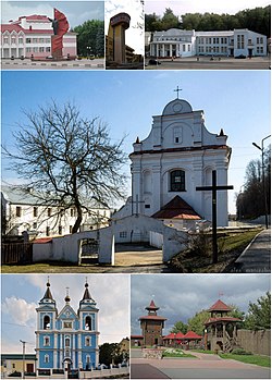
Mozir
|
Mazyr Belarusian: Мазы́р |
||
|---|---|---|
 |
||
|
||
| Coordinates: 52°03′N 29°15′E / 52.050°N 29.250°E | ||
| Country |
|
|
| Region | Gomel Region | |
| Mentioned | 1155 | |
| Area | ||
| • Total | 44.1381 km2 (17.0418 sq mi) | |
| Elevation | 160 m (520 ft) | |
| Population (2009) | ||
| • Total | 108,792 | |
| • Density | 2,500/km2 (6,400/sq mi) | |
| Time zone | FET (UTC+3) | |
| Postal code | 247760 | |
| Area code(s) | +375 2363 | |
| License plate | 3 | |
| Website | www.mymozyr.info | |
Mazyr (Belarusian: Мазы́р, pronounced [maˈzɨr]; Russian: Мозырь Mozir, Polish: Mozyrz) is a city in Gomel Region of Belarus on the Pripyat River about 210 kilometres (130 miles) east of Pinsk and 100 kilometres (62 miles) northwest of Chernobyl and is located at approximately 52°03′N 29°15′E / 52.050°N 29.250°E. The population is 111,770 (2004 estimate). The total urban area including Kalinkavichy across the river has a population of 150,000. Mozyr is known as a center of oil refining, machine building, and food processing in Belarus. It is home to one of the largest oil refineries in Belarus, pumping out 18 million metric tons per year. The Druzhba pipeline carries crude oil from Russia splitting in two at Mazyr. One pipeline branch is directed into Poland and the other one to Ukraine.
The right bank of the Pripyat River, where the city is located, is elevated above the left bank at substantial heights (up to 80 metres (262 feet)). The overfall of surface of that scale is assumed to be a consequence of a glaciation: the Pripyat River is running right along the edge where an ancient glacier was located. Since both banks of the river are sandy, the right bank is cut through by a number of great ravines (more than 2.5 km (1.6 mi) length, up to 200 metres (656 feet) width). The city is also located on the ravines, so its streets look much like streets of a mountain town. One of the ravines is proclaimed a reserve. Some of the nearby ravines are currently also equipped with ski lifts and transformed into skiing winter resorts.
...
Wikipedia


