Moyenmoutier
| Moyenmoutier | |
|---|---|

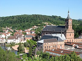
View of the town center and Moyenmoutier Abbey
|
|
| Coordinates: 48°22′50″N 6°54′51″E / 48.3806°N 6.9142°ECoordinates: 48°22′50″N 6°54′51″E / 48.3806°N 6.9142°E | |
| Country | France |
| Region | Grand Est |
| Department | Vosges |
| Arrondissement | Saint-Dié-des-Vosges |
| Canton | Raon-l'Étape |
| Intercommunality | CA Saint-Dié-des-Vosges |
| Government | |
| • Mayor (2008–2014) | Pascal Guy |
| Area1 | 34.21 km2 (13.21 sq mi) |
| Population (2006)2 | 3,395 |
| • Density | 99/km2 (260/sq mi) |
| Time zone | CET (UTC+1) |
| • Summer (DST) | CEST (UTC+2) |
| INSEE/Postal code | 88319 /88420 |
| Elevation | 285–642 m (935–2,106 ft) (avg. 320 m or 1,050 ft) |
|
1 French Land Register data, which excludes lakes, ponds, glaciers > 1 km² (0.386 sq mi or 247 acres) and river estuaries. 2Population without double counting: residents of multiple communes (e.g., students and military personnel) only counted once. |
|
1 French Land Register data, which excludes lakes, ponds, glaciers > 1 km² (0.386 sq mi or 247 acres) and river estuaries.
Moyenmoutier is a commune in the Vosges department in Grand Est in northeastern France.
Inhabitants are called Médianimonastériens.
The little town of Moyenmoutier is positioned along the lower part of the valley, at an average altitude of 320 meters. To the north-east, just over 5 kilometres (3 mi) away up the valley, is Senones. Further away are Saint-Dié-des-Vosges, 17 kilometres (11 mi) to the south and Nancy some 76 kilometres (47 mi) to the north-west.
Moyenmoutier is arranged into various quarters as follows:
The commune also includes several more isolated hamlets, including les Azelis, le Cadran Bleu, les Quatre Chemins, la Bergerie, la Pépinière, les Baraques and les Fossés.
The origin of the name Moyenmoutier is the obvious one. The founded by Saint Hydulphe in 671 was located between four others, at Senones to the east, Étival to the west, Saint-Dié to the south and (at Val-et-Châtillon) to the north. Taken together these five monasteries subsequently, in a more map conscious age, have become known as the Sacred Cross of Lorraine (la Croix Sacrée de Lorraine).
In 915 the abbey was pillaged and torched by Hungarians and Barbarian hordes: it was rebuilt around 960. In the 12th century Aubert of Paroye built a hilltop castle on the Rock of St Peter, but this was destroyed in the 13th century under orders from the Duke of Lorraine.
The monastery dominated local life, sharing the ups and downs of the ensuing centuries with the little town that surrounded it. By the end of the 16th century, with the religious world across western Europe undergoing the confrontation between the Protestant winds from Germany and the Counter Reformation forces confronting it, there was a feeling that monasticism in Moyenmoutier had fallen into a sorry state. The commendatory abbot of Moyenmoutier, who was also the Bishop of Verdun and commendatory abbot of the Monastery of St Vanne in Verdun, undertook to restore a more orderly existence to the monks under his authority. He entrusted the task to Dom Didier de La Cour. In 1604 the resulting new constitution of the Congrégation of St. Vanne and St. Hydulphe received papal approval. The reforms became an important element in the Counter Reformation, being copied by other Catholic religious houses and congregations including in 1621, most famously, the Congregation of St. Maur.
...
Wikipedia


