Mow Cop
| Mow Cop | |
|---|---|
 Mow Cop Castle |
|
| Mow Cop shown within Cheshire | |
| OS grid reference | SJ855573 |
| Civil parish | |
| District | |
| Shire county | |
| Region | |
| Country | England |
| Sovereign state | United Kingdom |
| Post town | STOKE-ON-TRENT |
| Postcode district | ST7 |
| Dialling code | 01782 |
| Police | Cheshire |
| Fire | Cheshire |
| Ambulance | North West |
| West Midlands | |
| EU Parliament |
North West England West Midlands |
| UK Parliament | |
Mow Cop /ˈmaʊˈkɒp/ is an isolated village which straddles the Cheshire–Staffordshire border, and is divided between the North West and West Midlands regions of England. It is 24 miles south of Manchester and 6 miles north of Stoke-on-Trent, lying on a steep hill of the same name rising up to 335m (1099ft) above sea level. The village fringes the Cheshire Plain to the west and the hills of the Staffordshire Moorlands to the east. For population details taken at the 2011 census see Kidsgrove.
The name is first recorded as "Mowel" around 1270 AD, and is believed to be derived from either the Anglo-Saxon Mūga-hyll, meaning "heap-hill", with copp = "head" added later, or the Common Celtic ancestor of Welsh moel (= hill), with Anglo-Saxon copp added later.
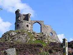
At the village's summit, men once quarried stone to make into querns, used since the Iron Age for milling corn; this trade ended during the Victorian period. The village also has a long history of coal mining. A 65 ft rock feature called the Old Man O'Mow sits in one of the quarry areas and is believed to be the site of an ancient cairn. The most dominant feature is Mow Cop Castle which is a folly of a ruined castle at the summit of the hill, built in 1754. Both Mow Cop and Old Man O'Mow are under the management of the National Trust and sit on the walking route of the Cheshire Gritstone Trail. The village was served by a railway station which was opened by the North Staffordshire Railway on 9 October 1848.
...
Wikipedia

