Mourenx
| Mourenx | ||
|---|---|---|

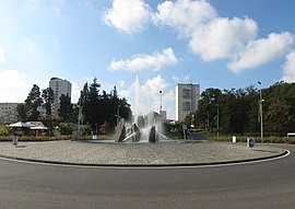
Main route entering Mourenx
|
||
|
||
| Coordinates: 43°22′46″N 0°36′25″W / 43.3794°N 0.6069°WCoordinates: 43°22′46″N 0°36′25″W / 43.3794°N 0.6069°W | ||
| Country | France | |
| Region | Nouvelle-Aquitaine | |
| Department | Pyrénées-Atlantiques | |
| Arrondissement | Pau | |
| Canton | Lagor | |
| Intercommunality | Lacq | |
| Government | ||
| • Mayor (2001–2008) | David Habib | |
| Area1 | 6 km2 (2 sq mi) | |
| Population (2006)2 | 7,735 | |
| • Density | 1,300/km2 (3,300/sq mi) | |
| Time zone | CET (UTC+1) | |
| • Summer (DST) | CEST (UTC+2) | |
| INSEE/Postal code | 64410 /64150 | |
| Elevation | 95–182 m (312–597 ft) (avg. 105 m or 344 ft) |
|
|
1 French Land Register data, which excludes lakes, ponds, glaciers > 1 km² (0.386 sq mi or 247 acres) and river estuaries. 2Population without double counting: residents of multiple communes (e.g., students and military personnel) only counted once. |
||
1 French Land Register data, which excludes lakes, ponds, glaciers > 1 km² (0.386 sq mi or 247 acres) and river estuaries.
Mourenx is a commune in the Pyrénées-Atlantiques department in south-western France.
A settlement of Mourengs existed in the eleventh century. A secular abbey existed, belonging to the Viscount of Béarn. In 1385 the village had 27 hearths.
Natural gas deposits were discovered in nearby Lacq in 1951. A new town was constructed in 1958 to provide accommodation for the workers required at the gas processing plant. The town was designed by architects and urbanists Coulon, Douillet and Maneval. It consisted of three groups of collective housing, three groups of family housing, all around a central area of support facilities.
The well-known French sociologist Henri Lefebvre carried out a study of Mourenx and its inhabitants at the time of its creation.
...
Wikipedia


