Mountain Pine Ridge
| Mountain Pine Ridge Forest Reserve | |
|---|---|
|
IUCN category IV (habitat/species management area)
|
|

Mountain Pine Ridge Forest Reserve
|
|
|
Map of Belize
|
|
| Location | Cayo District, Belize |
| Nearest city | Belmopan |
| Coordinates | 16°57′54″N 88°54′40″W / 16.965°N 88.911°WCoordinates: 16°57′54″N 88°54′40″W / 16.965°N 88.911°W |
| Area | 430 km2 (106,353 acres) |
| Established | 1944 |
Mountain Pine Ridge Forest Reserve is a nature reserve in the Cayo District of southern central Belize. It was established in 1944 to protect and manage the native Belizean pine forests. Its boundaries are poorly defined, but it is estimated to cover an area of 106,352.5 acres (430 km2), although much of the reserve has been leased.
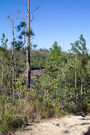
The reserve is predominantly pine forest (58.5%), primarily Honduras pine, Pinus caribaea var. hondurensis, but with a significant broadleaf forest component (36.8%). There are small areas of grassland (3.4%) and wetland (0.6%). Roads, rivers and other features make up the remainder of the area (10.9%). The climate is subtropical with a rainy season from July to February. During the dry season (February to May) temperatures may reach 39 °C (102 °F) with a humidity level of 70%.
The majority of the reserve is situated on a granite massif, with some areas of limestone in the west of the reserve (remnants of a limestone plateau laid during the Jurassic). Sinkholes and caves are common in the limestone areas. The underlying soils are predominantly sandy. The elevation of the reserve averages between 400 and 700 m (1,312 to 2,296 ft) with the highest point being Baldy Beacon at 1,017 m (3,336 ft), and dropping to 120 m (394 ft) at the lowest point on the Macal River.
The Macal River forms the boundaries of the reserve to the west and south and is fed by tributaries including Rio Frio, Rio On, Privassion Creek and Pinol Creek. To the north-east some small streams feed into Barton Creek.
Little is known of the early history of the area. The Maya had a city at Caracol on the borders of the modern reserve as early as 1200 BC, and Mayan artifacts discovered in Barton Creek Cave suggest that it was used as a ritual site. There is no mention of Mountain Pine Ridge in Hummell's 1921 report of Belizean forests, but it is believed he may have been the first forester to visit the area in 1897. To control increasing forestry activity in the area, a region of 1,504,000 acres (6,086 km2) was designated as forest reserve in October 1944, but despite fire control measures being established in 1945, much of the forest was destroyed by a fire in 1949. Few trees in the existing forest date to before this period. The reserve was reclassified in 1952 as a production forest and the 1950s saw the provision of roads and a landing strip. In 1959, the area of the reserve was reduced, losing some land to the neighbouring Sibun Forest Reserve. Hunting was banned in the reserve in 1978 in recognition of the nature conservation role that could be played by the reserve.
...
Wikipedia

