Mount Wilson (California)
| Mount Wilson | |
|---|---|

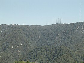
The north slope of Mount Wilson as seen from Angeles Crest Highway
|
|
| Highest point | |
| Elevation | 5,713 ft (1,741 m) NAVD 88 |
| Prominence | 150 ft (50 m) |
| Coordinates | 34°13′26″N 118°03′42″W / 34.223759025°N 118.061644914°WCoordinates: 34°13′26″N 118°03′42″W / 34.223759025°N 118.061644914°W |
| Geography | |
| Parent range | San Gabriel Mountains |
| Topo map | USGS Mount Wilson |
| Climbing | |
| Easiest route | Drive |
Mount Wilson is one of the better-known peaks of the San Gabriel Mountains, located within the San Gabriel Mountains National Monument and Angeles National Forest in Los Angeles County, California. With only minor topographical prominence the peak is not naturally noticeable from a distance, although it is easily identifiable due to the large number of antennas near its summit. It is a subsidiary peak of nearby San Gabriel Peak.
It is the location of the Mount Wilson Observatory, which is an important astronomical facility in Southern California with historic 60-inch (1,524 mm) and 100-inch (2,540 mm) telescopes, and 60-foot (18.3 m) and 150-foot (45.7 m) solar towers. The newer CHARA Array, run by Georgia State University, is also sited there and does important interferometric stellar research.
The summit is at 5,710 feet (1,740 m). While not the tallest peak in its vicinity, it is high enough in elevation that snow can sometimes interrupt astronomical activities on the mountain. All of the mountains south of the summit are far shorter leading to unobstructed views across the Los Angeles Basin, Orange County, the Inland Empire, and out to Ventura County, San Diego County and the Pacific Ocean. On most days Santa Catalina Island, California, some 65 miles south, is visible. On clear days, other Channel Islands visible include San Clemente Island at 95 miles, Santa Barbara Island at 76 miles, San Nicolas Island at 107 miles, Santa Cruz Island at 98 miles and San Miguel Island at 133 miles. At an elevation of 5,710 feet, the horizon on the ocean extends 92 miles.
...
Wikipedia

