Channel Islands of California
 |
|
| Geography | |
|---|---|
| Location | Pacific Ocean |
| Total islands | 8 |
| Area | 350.89 sq mi (908.8 km2) |
| Highest elevation | 2,429 ft (740.4 m) |
| Highest point | Devils Peak, Santa Cruz Island |
| Administration | |
|
United States
|
|
| State | California |
| Largest settlement | Avalon (pop. 3728) |
| Demographics | |
| Population | 4,603 (2010) |
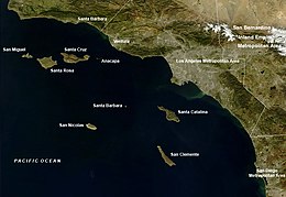
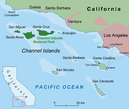
The Channel Islands of California are a chain of eight islands located in the Pacific Ocean off the coast of southern California along the Santa Barbara Channel in the United States of America. Five of the islands are part of Channel Islands National Park, and the waters surrounding these islands make up Channel Islands National Marine Sanctuary. The islands were first colonized by the Chumash and Tongva Native Americans 13,000 years ago, who were then displaced by European settlers who used the islands for fishing and agriculture. The U.S. military uses the islands as training grounds, weapons test sites, and as a strategic defensive location. The Channel Islands and the surrounding waters house a diverse ecosystem with many endemic species and subspecies.
Eight islands are split among the jurisdictions of three separate California counties: Santa Barbara County (four), Ventura County (two), and Los Angeles County (two). The islands are divided into two groups; the northern Channel Islands and the southern Channel Islands. The four northern Islands used to be a single landmass known as Santa Rosae.
The archipelago extends for 160 miles (257 km) between San Miguel Island in the north and San Clemente Island in the south. Together, the islands’ land area totals 221,331 acres (89,569 ha), or about 346 square miles (900 km2).
...
Wikipedia

