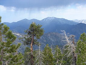
San Gabriel Mountains National Monument
| San Gabriel Mountains National Monument | |
|---|---|
|
IUCN category III (natural monument or feature)
|
|
 |
|
| Location | Los Angeles County, California, United States |
| Coordinates | 34°15′0″N 117°50′20″W / 34.25000°N 117.83889°WCoordinates: 34°15′0″N 117°50′20″W / 34.25000°N 117.83889°W |
| Area | 346,177 acres (140,093 ha) |
| Established | October 10, 2014 |
| Governing body | U.S. Forest Service |
| Website | San Gabriel Mountains National Monument |
The San Gabriel Mountains National Monument is a United States National Monument managed by the U.S. Forest Service, which encompasses parts of the Angeles National Forest and the San Bernardino National Forest in California. On October 10, 2014, President Barack Obama used his authority under the Antiquities Act to create the new monument, protecting 346,177 acres of public lands in the San Gabriel Mountains of the Transverse Ranges.
The monument covers the central and northern regions of the San Gabriel Mountains, extending west to east from Upper Sand Canyon at Little Tujunga Canyon Road to Telegraph Peak. It contains the Sheep Mountain Wilderness, the San Gabriel Wilderness, and Pleasant View Ridge Wilderness. Most of the major peaks of the San Gabriels are within the limits of the monument, including Mount San Antonio, Mount Baden-Powell, and Throop Peak. The Silver Moccasin Trail lies within the monument. The monument only covers a limited portion of the range's western extent, and much of the southern portion of the range has been excluded from the monument. It does not contain the Cucamonga Peak region.
The movement to further preserve the San Gabriel Mountains began in 2003 when then Congresswoman Hilda Solis initiated an environmental feasibility report to see if it was possible to increase protection by National Monument designation.
...
Wikipedia

